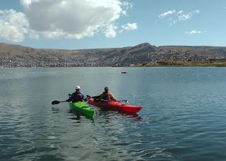
 Two explorers are about to embark on a paddling adventure around Lake Titicaca, the largest lake in South America and widely considered the highest navigable lake in the world. Their expedition is expected to take six weeks to complete and will cover 1100 km (683 miles) as they survey threats to the healthy of the lake, which is located at an altitude of 3812 meters (12,507 ft) in the Peruvian Andes.
Belgian adventurer Louis-Philippe Loncke and his partner Gadiel Sanchez Rivera will launch their kayak journey tomorrow, August 16. The plan is to circumnavigate the shoreline of the lake, taking GPS coordinates and extensive photographs to document the current position of the water, which can then be compared to future readings to determine if Titicaca is shrinking in size due to climate change. As temperatures warm up and glaciers in the Andes retreat, the rivers that feed the lake will provide less flow. That could spell trouble for the ecosystem around Lake Titicaca and the communities that fall on its shores.
Those same communities are already facing issues with water contamination due to chemicals and sewage being deposited directly into the water. The hope is that the expedition will help raise awareness of these threats to the lake and spur those communities to plan for water treatment options before it is too late. While paddling around Titicaca, the two explorers will discuss these issues with the local inhabitants, many of whom are already suffering as a result of pollution in the water.
Neither of these two men are strangers to exploration. Loncke, who is a member of the Explorers Club, once trekked solo and unsupported across the Simpson Desert in Australia and kayaked for 600 km (372 miles) along the waterways of his home country of Belgium. Rivera, who is better known by his nickname of Cho, spent two years walking the Amazon River with Ed Stafford a few years back. LouPhi and Cho have recently become fast friends and are now ready to embark on an adventure of their own.
A paddling expedition around Lake Titicaca sounds like it should be amazing and I'm actually surprised that no one has done it before. Taking GPS readings of the shore line may prove only marginally useful however as GPS readings are only accurate to within a few meters, which isn't necessarily close enough to track retreating water lines on the lake. The photographs they take will help to alleviate this somewhat and should prove useful in creating the first ever extensive inventory of the lake's shore. We'll be able to follow along with the adventure on LouPhi's blog where he will be documenting their findings and posting updates of their progress.

