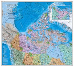
The Atlas of Canada recently published a beautiful new cartography product featuring the Canadian North in support of Natural Resources Canada and the Government of Canada’s Northern Strategy.

The new bilingual map product (available either in paper or digital formats) features the vast geography of the north from approximately 50° latitude and above. The map highlights populated places in all three Canadian territories, northern sections of the provinces, and also adjacent northern regions ofAlaska, Greenland andRussia.
The Canadian North is a fundamental part of our country, part of our heritage and key to our future. It has an extensive geography from the boreal forests north to the tundra, across the permafrost regions and the ice of the Arctic.
The Atlas of Canada provides Canadians with current accessible geographic information products covering the entire country. It was first published in print in 1906 and then in 1999 became one of the first online electronic atlases in the world. Today, the Atlas of Canada continues to provide Canadians with a diverse cartographic collection of maps, data, images and other related resources.
“The Atlas of Canada Web site will provide the most interesting, dynamic and comprehensive collection of maps and related information about Canada available anywhere on the Internet, with effective and intuitive tools for users to access them.”
The Atlas of Canada provide free downloads of new map of the Canadian North in either JPG or PDF versions. They no longer sell map products directly to the public but do make hard copy versions available to purchase through various dealers all across the country. So if you do not have the ability to print your own copies you can still get paper products.
To download any Atlas of CanadaMaps see: http://atlas.nrcan.gc.ca/site/english/dataservices/wall_maps/index.html
To purchase download any Atlas of Canada Maps see: http://atlas.nrcan.gc.ca/site/english/dataservices/wall_maps/purchase_info.html
Reference number: MCR0036
Size: 43.5 inches by 47.5 inches or 110.49 centimetres by 120.65 centimetres
Scale: 1:4 000 000
Published: 2012
Print Version:
Cat#: M114-25/2011
ISBN: 978-1-100-54028-3
PDF Version:
Cat#: M114-25/2011-PDF
ISBN: 978-1-100-54029-0

