The view ahead to the Major Mitchell Plateau
Well, I was going to continue writing up the second tilt of the Great South West Walk, but I've decided to take a break for a couple of posts and look at something a little different. How about a
Now, you'll find this walk in the ubiquitous Glenn 'Guru of Good Times' Tempest's book, 'Daywalks Around Victoria'. Essentially, it's the best bits of a three day circuit all packed together in one insane free-for-all day and the bare bones of it are the following statistics. 19.2 kms long, rated as 'difficult' and suggested time of seven hours to complete. Mm... I'll return to that later.
If you were attentive you would have noted the first paragraph included the word 'longish'. I think my write-up for Mount Langi Ghiran is the largest post I've ever done, but I don't want to rest on my laurels, so I've decided to have a shot at the title and do a bigger one. This walk certainly deserves it!
Firstly, before we go anywhere near a set of boots, how about a quick quiz? See how you go with the following questions.
A. As the Imperial Guard broke under fire at the Battle of Waterloo, Napoleon was heard to say, "Je pensais qu'ils étaient un peu plus difficile que cela? La seule chose qui leur manque des sacs à main" (I thought they were a little tougher than that? The only thing they are lacking are handbags.)
B. My mother was an unmedicated schizophrenic who believed she was programmed by the Queen for lifetime of misery.
C. I'm so well-hung I buy my socks in threes.
D. The Major Mitchell Plateau walk has been closed since January 2011 and will remain so until further notice.
E. Both B and D.
F. All of the above.
So, as you appear to be flummoxed and scratching your head I'll give you the answer. It is of course,

I believe the common definition of 'temporary' is 'lasting for a limited period of time'. Is 18 months temporary? Seeing how the earth is 4.54 billion years old, I suppose Parks Victoria use the word 'temporary' by that method? So, if you do decide to wait for this walk to re-open, you'll find it a lot easier, as you'd use your own personal jet-pack and not have to worry about your feet touching the ground.
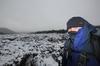
Anyway, so it's shut, but that didn't deter Smuffin who was wheeled out for this Spring walk, although the date did cause a bit of angst, as it was actually the 1st of September. That's Spring? Right? I informed him that we didn't have to worry about the weather, as winter was over, to which he replied, "Yeah, there's such a difference in temperature eight hours after winter finished". He's pedantic about these things.
What else? This walk is not a circuit, so we were again utilising Lady Smuffin who was in charge of vehicle duties for dropping off and picking up at the end. Oh yeah, before getting to the walking part, we weren't sure about water across the plateau, so we loaded up with plenty. I was carrying five litres, which ended up being overkill, as there were points where we were nearly drowning.
So, on a lovely Spring day we were dropped off on the road to Mount William which is the first interest of the day. The drop off point is certainly high enough to have clouds drifting by one minute...

The closed road which leads to Mount William
...and bright sunshine the next.

Yep, the clouds lifted as quickly as that...
It's actually a steepish stroll, but it's very gentlemanly to be on a road that leads to the 1167 metres Mount William, which is the equal highest point of the Grampians. Ah yes, but don't go there expecting a wondrous natural feeling on the summit. There's the slight problem of this at the top...

Tower atop Mount William summit
Sorry about the insane blue caused by the polarizer, but in my eyes the main problem is that it's not blue enough. Anyway, the summit does have the odd piece of equipment, but there are some nice views, although I'm not quite sure what I was looking at. I felt I needed a welder's mask due the enormous glare caused by a solid layer of cloud below the summit. It was the view one would see from an aeroplane and did make for a spectacular sight (if you were there, as the photos look absurd).

See what I mean? What is that?
Yeah, the light is ridiculous and I should have put the camera on the little used 'atomic blast flash' exposure setting. Here's another look at whiteness...

Cloud layer from Mount William summit.
This was the end of the road for the day and the proper walking would begin. We located the track okay, although Parks Victoria are pretty keen in not helping anyone find it. All of the information plaques appeared to have been removed, so we were lucky Smuffin utilised himself as the sign indicating direction of travel. Oh yeah, ignore the standard, 'cock drawn on sign' which is an old favorite.

Head that way.
Successfully finding the track means you've officially defeated the 'no sign' defences, but that's not the end as of it, as you'll come across some more warnings...

Oh yeah, the first day of the new season and Smuffin was feeling a little feisty...

We strolled on, but not knowing what was ahead, I wondered what 'required safety works' needed to be done which has caused the walk to be closed. Was there some sort of cataclysmic bear-pit filled with punji stakes that we'd have to negotiate? Was Tony Abbott out there frothing at the mouth and jabbing passersby with a pitchfork blaming the closed track on the carbon tax? These are the sort of things I was worried about encountering. Being wild men though, we continued on and the clouds continued to roll through...

...from the cliffs next to us.

Even with the clouds obscuring things, the views through this section are fantastic. Standard Grampians fair of vertical cliffs by the dozen were along this walk. Not that we could see the ground very often at them...

That's a long way down. I think.

It was on one of these cliffs shrouded in clouds that Smuffin stopped at to have a look and as I approached to where he was standing I stumbled a little. I did manage to regain control instead of slamming into his back and hurling him into the abyss. It was an 'interesting' moment and if he had gone over I informed him that I'd completely lie at the subsequent coronial inquest by saying, "I've no idea what happened. One minute he was there and the next he was gone!" Upon hearing this Smuffin said, "Prick!" which means, "That's okay Greg, I'd do the same".

There's something out there somewhere...
Actually, the photos don't really give a sense of scale regarding these cliffs. The drops were long and vertical, not to mention slightly eerie with clouds floating past. Smuffin suggested putting something in the picture, such as my foot to create some scale. All it did though was give me the thought that trying to balance on one leg whilst taking a photo on the edge of an enormous cliff wasn't the best idea. It was ludicrous, but I did it anyway.

Does this now make the whole sense of scale any easier...?
We survived that cliff viewing and now began an enormously steep descent into Boundary Gap.

Starting to descend into Boundary Gap
Do you want to know how steep? Well, it was vertical enough for me to forget about taking photos and concentrate on just hanging onto trees as we plummeted back into a forest. The track consisted of wet rocks and tree roots which left me pondering of not if, but when I'd take a spill.
It was slow going and a killer on the knees, but somehow we made it to the gap in one piece. Guess what? Well, as is the way, as soon as the track levelled off and having survived an hour of vertical descent I fell over. It seems as soon as I relax I tumble. It's always happened and this was no different. The fiasco way though is to pause for a moment and take a picture from the point of impact...

In a pathetic attempt to break my fall, my hand hit the ground pretty hard, but I was impressed to see that there was no blood. Only a bit of dirt...

We were now at Boundary Gap and it was a chance to relax with a sandwich before the next instalment, which looked like an equally insane steep climb to get out of the gap on the other side to reach the plateau. In the upcoming section the walk notes mention, "...you'll need to scramble up a few small sandstone steps..." I did wonder what that meant as the top wasn't visible from the forest, but we began to climb...

Holding the camera level to show the steepness...
...and as the trees thinned out we could see a band of scrub and rocks to negotiate.

The top is up there somewhere...
The clearer view also give us an opportunity to look back at where we had come. The forested hillside in this photo gives an indication of the steepness into Boundary Gap.

Looking back at the descent into Boundary Gap
The rough track came to an end at a series of rocks and it was a matter of hauling ourselves up. The route was sort of clear cut, but we found it slow going negotiating this section...

Looking up at the rocks to climb...


Part of the rock scramble to the top...
Mind you, I was taking my time as the view was pretty spectacular...

Views to the west...

Views to the east...
I really wish I was doing this crap when I was lean and mean in my twenties instead of being fat and friendly in my forties. This took us quite a long time and at this point looking back, it was absurd that the towers on top of Mount William seemed so close. There's a reason for this though and that's because they were. Somehow we'd spent half a day walking and only covered five kms of the 19 we needed to walk. Was I concerned about the time taken? No, not really, as I thought once we'd reach the plateau again we'd make it up pretty quickly. Oh yeah, take note of that last sentence.
The climbing continued, as we weaved around enormous rocks...

The route up is through the middle...

...through there...

...and looking back from the photo above.
There were a few more views back...

...and finally the top was in sight.

The top is just up there...
Finally we dragged ourselves up and hit flat ground. It was a fantastic little climb that was lots of fun and the only injury of note was a bit of blood on Smuffin. Then again, he's bled on every walk I've been on, so it was no big deal.

Bleeding arm
Upon reaching the plateau we had to make up some time. Fast walking was difficult for all sorts of reasons though. The freakishly good views weren't helping and it was a shame we couldn't stop for a while to take in the surroundings.

Actually, our pace didn't really improve much throughout the day. Initially the route ahead is pretty clear, but track markings are minimal. There was this sloppily painted arrow which was one of the few we saw across the plateau...

Don't put so much on the brush.
We continued on through sections like this...

...whilst diverting at points to look down cliffs.

I was carrying the Spatial Visions map of the Southern Grampians which details the Major Mitchell Plateau walk as a three day circuit. The 'First Wannon hiker campsite' is the first nights stop from that particular walk and we'd aimed to make it our lunch spot. We descended down into the clearing and it would be a great spot to camp. What surprised me was the amount of water running through the creek nearby and if I knew it was that plentiful I wouldn't have lugged five litres for the day. It looked pretty clear as well.

Water at First Wannon campsite
Unfortunately for us, the plan to take a reasonable break went out the window due to our slow pace to that point. We stopped to eat a sandwich, before getting back into it with the next point of interest being the peak of Durd-Durd which is at an identical height of Mount William of 1167 metres.
I should mention this now before I forget. If you're doing this walk and happen to own a pair of gaiters I'd suggest wearing them. The entire plateau is covered with a particularly annoying plant that is prickly as hell (I was going to look up what type it is, but I couldn't be bothered!). It seemed we were walking through this type of plant for hours and the end result was the front of my legs were covered in small cuts. Yeah, you'll look more manly like I did without gaiters, but you're legs won't be shredded by the scrub. I definitely know what I'd do next time.
There's a gradual climb out of the campsite area and any thought of making up time were gone, as the route ahead is not the clearest. I had the GPS download from the 'Temple of Tempest's' website of Open Spaces Books to guide us. In saying that though, it's unlikely you'd get lost as one just has to follow the line of enormous cliffs to the east. If you fall over the cliffs then I suggest you've become lost, not to mention dead.
The thing is the terrain didn't allow our rickety ankles to pick up the pace. It's all rocks and small scrub to push through with our eyes on small rock cairns placed by other punters to lead us on.

See the rock cairn? Head over there...
The other problem was the views and it's a pity we had to keep pushing as it would have been nice to sit down for a while and take it all in...


We'd find sections of clear ground...

...before suddenly having to wade through trees chest deep.

Straight ahead...
How many times have I said the views were spectacular? I won't even mention that any more and just saturate the place with photos for a while.


I was amazed at one point to see a yellow track marker, as I don't think we'd seen one for a few hours. I think if there's only one every two hours then they're probably not worth the trouble? It was such an exciting find, I made sure I took a photo.

We continued on passing bare branched trees...

...some open rocky ground...

...and views of the Mount William and Serra Range covered in cloud.

I was wondering if the summit of Durd-Durd would be obvious, as there was no particular peak standing out in front of us. Eventually we spotted a rock cairn which marked the spot...

Rock cairn on Durd-Durd summit
...to which Smuffin added another.

We were now at the equal highest point of the Grampians and it was an isolated place. The views were amazing in all directions, but frustratingly for us we couldn't stop to enjoy them. It was now late in the day and believe it or not, but we'd only covered ten kilometres and had another nine to go!! We still had to negotiate Banksia Hill which sits a short distance past Durd-Durd, but what was worse was it was noted as, "...descent on the other side, however, is very steep and some scrambling may be required..."
So, without even dropping packs we had a quick snack and kept walking with Banksia Hill now appearing before us and amongst a sea of rocks and trees it didn't appear to be very appetizing.

Next stop: Banksia Hill
That descent mentioned in the notes is not the spot we wanted to be negotiating with fading light, so we were trying to move a little quicker, but it wasn't really working. Especially when Smuffin's phone rang and he answered in case it was a call of urgency, but was greeted with someone in broken English saying, "Sir! Glad to speak you. Your computer has been infected and important to turn it off now and follow my instructions!!" Smuffin was getting a little fired up by this call in the middle of the nowhere and replied with, "$#@% YOU, C$#^*****R, YOU $#@$%^%$*%^&**" There were more symbols, but I'm running out of keyboard and the diatribe was too long. The end result is that Smuffin didn't turn off his computer.
Remember that business about Banksia Hill not being very appetizing? Well, it was worse than that. There's no real track and it's a matter of clambering over boulders, pushing through trees and trying to climb at the same time. Frankly it's a prick of spot to try and get over quickly. Light was low and if I could be bothered, photos were now being taken with a flash.

Banksia Hill terrain

Wallaby in the trees
If there was a track, we lost it through here and started to descend too quickly. We realised this when the ground began to drop alarmingly, so we headed back up and successfully found a rough track that follows the ridgeline down. Well, that was until it also vanishes and a freakishly steep section appears. How steep? Well, it felt like we were about to go down a chimney rather than a track...

Start of the chimney looking vertical path...
I'm not sure how I was going to stay upright, so I elected to use the 'on the arse' method which for me was the only safe way down. If anything, it reminded me of the rock bands on the Helicopter Spur which I'd walked up earlier in the year. On this section, going up would be hideous, but at least one isn't about to plummet in a limb shredding fall which our descent felt like. Going down was easier on the lungs, but a lot higher in the petrified factor. I took a couple of photos with the flash to take my mind off the trauma.

Looking down...

...and back up.
In the end the chimney levelled off a little and for the first time in half a day, a regular path appeared which led us down to a large clearing below Banksia Hill. It was a relief and we looked back to see the hill bathed in the glow of the setting sun.

Our walk was done and the sunlight faded quickly which meant we had no option other than take a shortcut. We took the Stockyard Track which led to the Mafeking Picnic Ground, rather than the walks intended route to the Jimmy Creek Campground. This chopped off three kilometres, but even then it was dark with headlamps on when we met up with Lady Smuffin again.
In wrapping up this extravaganza, here's the GPS reading for the day...
In summing up, I think it's easily one of the best walks I've done. It had it all and the only pity was that it seemed too much to fit in for one day. The overnight hike method would allow one to sit back a bit and relax. Oh yeah, the main problem with that though is that the walk's closed. It's earmarked to be part of the long distance Grampians Peak Trail, but who knows when that's meant to kick off. A few more years at least? A couple more billion? By the way, I mentioned earlier about the signs which indicated flood damage along the way and I guess I must have been asleep, as I didn't see anything frightening.
Now, do you notice one thing about that GPS reading? It took us 9 hours 18 minutes and we took the shortcut! We were only averaging 1.9 kms an hour and I think if one really wants to enjoy the freakish views then anything up to 10 hours might be a good figure. Don't forget I'm talking our pace, but I'm not sure how one gets up to three kms an hour on that terrain? What's even sillier, is that in a post on his blog Glenn Tempest did the entire thing in six hours! I asked Smuffin where we went wrong and he let me know what the problem was when he came across this picture. I think this explains the whole thing. Here's Glenn after another hike...

Glenn Tempest