Recently I had an opportunity to talk ‘one on one’ with Arthur Berrill, CTO of DMTI Spatial; a Canadian geomatics based company that has been a leader in the Location Business for several years. Arthur leads DMTI’s software development and technology group and has over 25 years of experience managing architecture, design and development of large spatial software systems. His team takes customer business challenges and develops spatial solutions that help resolve their problems.
DMTI Spatial is a Canadian based company that has been providing industry-leading enterprise Location Economics solutions for almost two decades. They started off by designing a comprehensive and tightly integrated national street network database known as CanMap®, and have evolved to integrate Location Economic solutions through Location Hub® combined with a database of unique address identifiers (UAID). – More details available from http://www.dmtispatial.com

I started off by letting Arthur know that as I was not really interested in doing a traditional interview but rather wanted an opportunity where he could help illustrate how ‘the Location Concept’ has been driving the success of DMTI in Canada. Then through a detailed conversation combined with a full product review I would be able to help the Canadian GIS & Geomatics readers to see how DMTI Spatial has been able to unlock the ‘Power of Location Economics’. Arthur graciously provided time for a detailed discussion, some literature and use of DMTI‘s Location Hub® Portal.
DMTI Spatial has been a frequent contributor to the free press release section on CanadianGIS.com so I was already aware of many of their products like the CanMap® geospatial datasets and how the Spatial Mapping Academic Research Tools (SMART) Program has been benefiting Canadians. Therefore we did not discuss much about other products and jumped right into how critical location based information can help make important planning decisions affecting our lives and what role DMTI’s Location Hub® Portal can play.
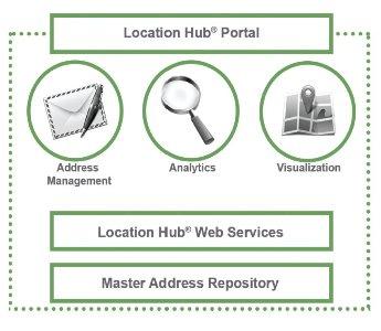
Arthur explained that Location Hub® is like an umbrella name or brand for a software-as-a-service (SaaS) platform that DMTI uses to incorporate a suite of products together into an easy to use self-serve portal, allowing bulk processing of address data. It could probably be simplified into two main components; an application side and a web services side. Together they provide clients the functionality that allows them to tap into accurate, current and reliable frequently updated location data, and perform spatial location analysis all from a simple intuitive interface that is available at any time.
 Tweet
Tweet
Unlike traditional GIS that is typically built around X, Y coordinate values with attribute information and designed for more technical people whereas location analytic services uses an address as the key approach to connect attributes while defining the location spatially at the same time.
When you stop and think about it, almost nothing in everyday life uses coordinates to define locations, yet nearly all data contains address based information, therefore it makes perfect sense to have Location Hub® start with the addresses and then build a GIS behind the scenes, leveraging the most comprehensive base data available in Canada. This is perhaps one of the key components of Location Hub®, rather than referencing a single data source, it leverages DMTI’s master address repository, an extensive data base of data, kept current through a rapid, agile, frequent update cycle.
“The Master Address Repository is the largest nationally sourced Canadian geospatial database cross-referenced from more than 7,300 federal, municipal and public partnerships. The data is further augmented through content provided by our partner ecosystem to provide a single point of reference for address and address related content such as name and phone number, land use, property type, demographics, property details and much more.”
 End users (who most often do not have much or any GIS technical background) are then supplied with attribute rich properly formatted geocoded spatial data that defines location while telling a story about those locations and the information within. After the input data is cleaned, formatted and processed, any gaps found within the uploaded files are filled in to include any missing addresses within the same geographic boundaries and duplicated data is consolidated or removed.
The target audience for Location Hub® has been typically commerce, enterprise and government but could virtually be anybody that had a database or spreadsheet of address based information. Many organizations have large data sets or lists of address but no way of providing standardized data matched or processed with accurately up to date base-data.
Built around a philosophy of the end user (What do they need? What could they use?), Location Hub® has been carefully planned with the “customer” in mind. Delivered through an interactive web interface, that is typically different than most traditionally GIS software, designed simple enough that almost anybody can use it. All the different address recognition algorithms are hidden behind the scenes so no one needs to know which ones they should be using and just feed in the data and the decisions with results are provided through end data and a detailed report.
DMTI Spatial claims that their location success lies in how they leverage technology expertise, a strong partner network and a reliable Canada-wide address database. They also claim that quality, precision and the industry’s strongest address recognition engine, make Location Hub® Canada’s most trusted source for location-based information.

Next in part II of this feature I will take a closer look at the Location Hub® Portal to check out the simple, intuitive interface with lightning speed processing and see how well it performs at cleaning, standardizing, validating and geocoding address records. And see how well it provides the ‘Power of Location’.
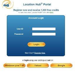
DMTI Spatial offer free trials of the Location Hub® Portal and like most of my product reviews I always encourage others to try out the service or product for themselves, all you need to get started is either a CSV or XLS file containing address based data. To register for immediate access to a free trial go to https://lhp.dmtispatial.com/Registration/Register.aspx
Click Here [available soon] to continue to Part II of Using Location Hub to Unlock the Power of Location Economics – “Location Hub® Product Review” or Click Here to return to Main Feature Page

