Introduction
Maps are not just tools; they are keys to unlock the secrets of the land. Topographic maps, in particular, can open up a whole new world for the curious explorer. If you’re a hiker, map enthusiast, or simply someone keen to navigate the world more effectively, HiiKER and its vast selection of premium topographic maps will prove indispensable. Let’s explore the art and science of understanding topographic maps and how HiiKER can elevate your navigation skills.
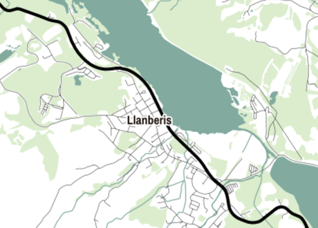
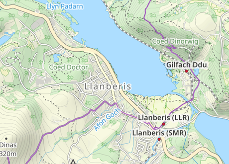
Firstly, let’s start with a basic map. Below is a sample of a very basic open street map. There is not much detail about the land here, other than that there is a lake, a town and some other roads. This kind of map might be ok for planning a driving route. But for Hiking, we are going to need a bit more detail.
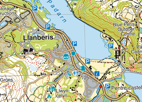
Next we have OpenStreetMaps Outdoor layer. This is a bit better. Now we can see contour lines, forests and possible hiking trails and tracks.
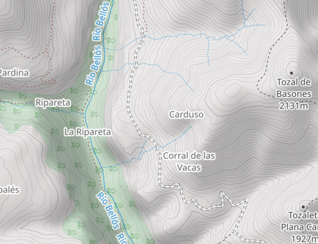
This is clearly a huge improvement on the first map. And includes some vital information for hikers and walkers taking to the hills. This is why we are offering this map layer for free on HiiKER.
But to really understand the land around you as a Hiker, you will not get a better experience than by using topographic maps. Let’s explore the benefits of these maps and how using them with HiiKER can unlock the Navigator in you!
The Basics of Topographic Maps
Topographic maps depict the three-dimensional features of the terrain in a two-dimensional format. They represent elevations, slopes, and depressions, providing a detailed picture of the landscape’s physical features, such as hills, valleys, and rivers. The essential elements of a topographic map include contour lines, scales, symbols, and grids.
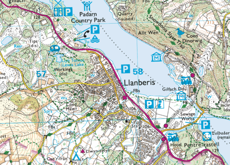
Contour Lines
Contours are lines drawn on the map connecting points of equal height. They depict the land’s shape and elevation, providing a visual understanding of the terrain’s ups and downs. By studying contour lines, you can get a sense of how steep or gentle a hill is, where the high points and low points are, and how energy-demanding your hike may be.
Scale
A map’s scale represents the relationship between a distance on the map and the corresponding distance on the ground. For instance, a 1:50,000 scale means that 1 cm on the map equals 50,000 cm (or 500 m) on the ground. A smaller scale map shows a larger area with less detail, while a larger scale map shows a smaller area with more detail.
Maps with a 1:25,000 scale are considered large scale maps, which provide a much closer look at the terrain. This means that 1 cm on the map equals 25,000 cm (or 250 m) on the ground. This scale is especially beneficial for hikers as it shows more detail, including smaller paths, more detailed contours, and often additional features such as fences, walls, and individual buildings. This level of detail can provide hikers with valuable information for navigation and help them better understand the terrain they will be traversing.
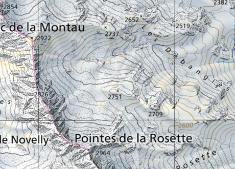
Normally with 1:25,000 scale maps, they cover a much smaller area than 1:50,000. But with HiiKER, you can zoom in and out of a particular area seamlessly.
Symbols and Grids
Symbols are used on maps to denote features such as buildings, campsites, trails, bodies of water, and landmarks. These are typically laid out and described in the map legend. This is information that we will be bringing to HiiKER very soon.
Grids, typically latitude and longitude lines or are oriented based on a local grid projection (e.g. Irish Grid Reference, British Grid Reference), help locate specific points on the map.
The Superiority of Topographic Maps for Hikers
While OpenStreetMap and similar platforms offer basic geographic information, they often fall short in providing the depth of data that hikers need for safe and enjoyable expeditions. This is where topographic maps, like those from EastWest Mapping and Harvey Maps, truly shine.
These topographic maps offer a level of detail unmatched by basic street maps. They showcase elevation data through contour lines, allowing hikers to understand the terrain’s intricacies and plan their routes more effectively. Whether you’re navigating steep ascents, trying to avoid heavily forested areas, or looking for water sources, this data is indispensable.
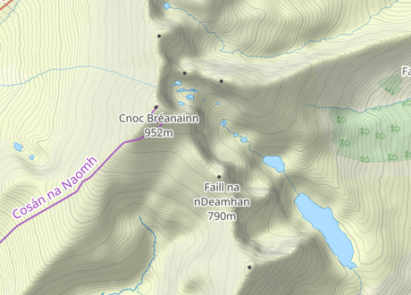
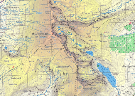
Furthermore, these maps often include symbols for hiking trails, campsites, water sources, viewpoints, and potential hazards. They also use a high-resolution scale that provides a more detailed view of the landscape, crucial for remote or challenging hikes.
In essence, EastWest Mapping, Harvey Maps, and similar topographic maps are designed with the outdoor enthusiast in mind. They provide a depth of information and accuracy that elevates them beyond basic street maps, making them an essential tool for any hiker.
Understanding Topographic Maps with HiiKER
HiiKER takes the power of topographic maps and delivers it right to your phone. Here’s how:
- Premium Map Selection: HiiKER offers a huge selection of premium topographic maps, including Ordnance Survey and EastWest Mapping. These maps provide high-quality, detailed information that’s invaluable for hiking.
- Offline Access: A significant advantage of using HiiKER is the ability to download maps for offline use. No matter where you are or how weak your signal may be, your topographic map will always be accessible.
- Custom Route Planning: With HiiKER, you can plan your routes on topographic maps. This feature gives you control over your hike, allowing you to choose your path based on the terrain and your ability.
- Easy Navigation: Using HiiKER’s interface, you can easily zoom in and out on the map, shifting your view between a broad overview and intricate details.
- Education: HiiKER is committed to educating hikers about navigation and map reading. Whether you’re a beginner or an experienced hiker, you’ll find valuable resources to deepen your understanding of topographic maps.
Conclusion
Navigating with topographic maps can transform your hiking experience, turning it from a simple walk into a deeper connection with the landscape. HiiKER’s wealth of topographic maps and intuitive features makes it an ideal companion for the trail, offering valuable tools to unleash your inner map enthusiast. So download a map, lace up your boots, and let your adventure begin!
Click here to see the full list of Premium Topographic maps available on HiiKER
