HiiKER, the go-to app for hiking enthusiasts around the globe, has just added Lantmäteriet maps, opening up new horizons for hikers interested in exploring Sweden’s breathtaking landscapes. This partnership marks a significant milestone in HiiKER’s mission to provide hikers with the most comprehensive and user-friendly navigation tools.
Bridging HiiKER and Lantmäteriet: A Leap Forward
Lantmäteriet, Sweden’s official mapping authority, has long been recognized for its detailed and accurate maps. By incorporating Lantmäteriet’s data into the HiiKER app, users can now access unparalleled detail and precision when planning their hikes across Sweden’s diverse terrains—from the rugged mountains of the Scandinavian Range to the serene shores of the Baltic Sea.
What This Means for Hikers
The integration of Lantmäteriet maps into HiiKER significantly enhances the hiking experience in Sweden by offering:
- Unmatched Detail: Explore trails with maps that provide extraordinary detail, ensuring hikers can navigate Sweden’s natural landscapes with confidence.
- Comprehensive Coverage: From iconic long-distance trails to hidden gems waiting to be discovered, hikers have access to a vast array of routes.
- Up-to-Date Information: Enjoy the latest updates on trails, terrain, and landmarks, thanks to Lantmäteriet’s commitment to accuracy.
- Planning Made Easy: HiiKER’s features, combined with Lantmäteriet’s precision, make planning your next adventure a breeze, whether you’re tackling a challenging hike or a leisurely walk.
 Stunning Northern Lights as seen from the Kungsleden (Kings road) in Northern Sweden
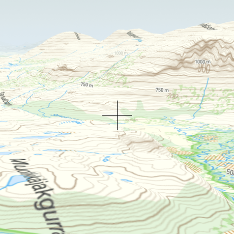
Lantmäteriet maps exclusively available in 3D on HiiKER
Moreover, this partnership uniquely positions HiiKER as the sole platform offering Lantmäteriet maps in 3D, an exclusive feature that elevates the mapping experience to a whole new level. This groundbreaking capability allows hikers to visualize their routes in stunning detail, offering a perspective that closely mirrors the real-world terrain of Sweden’s diverse landscapes.
From the towering peaks of the north to the rolling hills and deep forests of the south, users can now immerse themselves in a three-dimensional planning experience. This not only enhances route planning but also significantly aids in navigation, making it easier for adventurers to assess the terrain ahead.
 Cross-section of Lantmäteriet maps in 3d on HiiKER
The introduction of 3D Lantmäteriet maps on HiiKER not only sets a new standard for outdoor navigation apps but also underscores the commitment of both HiiKER and Lantmäteriet to providing hikers with innovative tools that enrich their exploration of Sweden’s natural beauty.
Celebrating Sweden’s Trails
Sweden’s trails offer something for everyone, and with the addition of Lantmäteriet maps, HiiKER is excited to bring these adventures to a wider audience. Hikers can immerse themselves in the natural beauty and historical richness of Sweden, from the legendary Kungsleden in the north to the picturesque Skåneleden in the south.
Commitment to Outdoor Exploration
This collaboration reinforces HiiKER’s commitment to making outdoor exploration more accessible and enjoyable. By bringing together HiiKER’s innovative app features with Lantmäteriet’s authoritative mapping data, the partnership aims to inspire more people to explore the great outdoors, equipped with the best tools for the journey.
Get Ready to Explore
The release of Lantmäteriet maps on HiiKER is just the beginning of a new chapter in hiking in Sweden. As HiiKER continues to expand its map offerings and features, the community of outdoor enthusiasts can look forward to even more exciting developments.
