HiiKER is excited to announce a transformative addition to its app: the integration of Anavasi maps, Greece’s premier cartography service known for its detailed and accurate outdoor maps.
This partnership is set to revolutionize the hiking experience in Greece, providing enthusiasts with the tools they need to explore the country’s legendary landscapes—from the rugged mountains of Crete to the tranquil paths of the Cyclades.
A Seamless Integration of Precision and Functionality
Anavasi, renowned for its dedication to mapping Greece’s diverse terrains, brings a wealth of geographic information that is both precise and reliable. By incorporating Anavasi’s maps into the HiiKER platform, users gain access to a level of detail that enhances their navigation capabilities significantly, ensuring a safer and more enjoyable hiking experience.
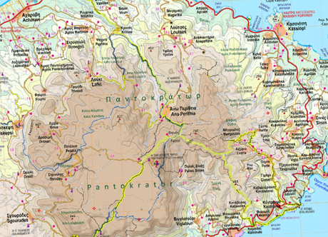
 Northeastern Corfu, Greece – as illustrated on Anavasi maps of the area. Now available on HiiKER
Enhanced Features for Hikers
The inclusion of Anavasi maps on HiiKER offers several key advantages to hikers looking to explore Greece:
- Superior Map Detail: Experience Greece’s natural beauty with an unprecedented clarity, from marked trails in national parks like Olympus and Parnitha, to hidden paths known only to locals.
- Extensive Coverage: Whether you’re venturing into the remote mountain ranges or coastal trails, these maps provide comprehensive coverage of Greece’s vast hiking terrain.
- Current Trail Information: Stay updated with the latest trail data, including changes due to weather or environmental factors, ensuring you have the most current information at your fingertips.
- User-Friendly Planning Tools: Combine HiiKER’s intuitive planning features with Anavasi’s detailed maps to easily plot your next adventure, manage itineraries, and track your progress.
Exclusive 3D Mapping Technology
HiiKER is also proud to be the exclusive provider of Anavasi maps in 3D. This feature transforms the hiking preparation process, allowing users to visualize their routes with dynamic, three-dimensional imagery. This immersive tool helps hikers better understand the terrain, prepare for elevation changes, and plan their journeys with greater confidence.
Promoting Outdoor Exploration in Greece
This partnership underscores HiiKER’s commitment to enhancing the global hiking community’s access to quality mapping resources. For the adventurous spirits drawn to Greece’s historic and diverse landscapes, these maps offer an invaluable resource, encouraging more people to explore the outdoors with enhanced safety and awareness.
Hikers on the Corfu trail.Get Ready for Your Greek Adventure
With the launch of Anavasi maps on HiiKER, prepare to embark on a journey through some of the world’s most storied hiking trails. Whether you are tackling the rugged terrains of the Greek mainland or tracing the serene footpaths on the islands, HiiKER equipped with Anavasi maps is your ultimate guide to a spectacular adventure.
Embrace the spirit of adventure with HiiKER and Anavasi—where every trail leads to discovery, and every hike tells a story of Greece’s enchanting wilderness.
