Ever since I reviewed the GEONB online mapping application by Service New Brunswick (SNB) and started to investigate various Canadian Open Data Sources, emails have been flooding my inbox with information about other Canadian GIS resources that I should share with all the CanadianGIS.com viewers [Thanks for that! And keep them coming!].
So in an effort to fulfill those requests, I have been taken some time to review some of the various technology and available data sets from across Canada and continue reviewing them in the GIS data section of the web site throughout the next few months. For one, to learn how well other sites compare (since SNB has set the bar pretty high) and then also to ensure that information about these great GIS resources are shared with others in the Canadian GIS community who can make use of them After all it is one thing to have great GIS information available but it is even better when people know about it.
Among some of the recent responses was an email from the City of Niagara Falls providing me with information about their Interactive Mapping Service (IMS) known as the Falls Viewer, their Open Data sets and various GIS accomplishments by the Information Systems division. So I took some time, read the provided information, explored the website, tested out the online applications, downloaded some files and this is what I learned:
Niagara Falls, Ontario is located a historical Canadian city located on the Niagara River in the Golden Horseshoe region. It covers a land area of approximately 212 square kilometers including both urban and rural regions; it was incorporated in 1903 and has over 82,500 residents. This historical border city is most known for the world famous set of waterfalls, the American falls and the Horseshoe falls. These bring mass amounts of visitors to the region making it on of the major tourist attractions in the world.

The City of Niagara Falls state that they are committed to improving services to their citizens, providing transparency and showing accountability with the most innovative and cost effective methods that they can provide. One of their newest initiative is to provide Open Data (the capacity to provide online access to internal data in a standards compliant Web 2.0 way) on-line. They have designed their website to support the publication and distribution of public information in both viewable IMS, and also in downloadable SHP & PDF formats. They are small but they hope that their efforts in the open government arena will help make them stand out from other municipalities.
A versatile Information Systems division creates and maintains GIS data for the municipality. They take advantage of the best software resources for their projects including Manifold, Autodesk Map 3D and Symposium plus various in house developed software applications. Windows operating systems are utilized with a SQL Server as the main database platform and most of their applications are running in 64 bit mode.

Their website provides users with a variety of pre-made maps available in PDF format (such as a base map, zoning maps and a street map), a data catalog of various downloadable data sets and also an Interactive Web Mapping Service called the Falls Viewer where users can create their own maps in their browser. There is also an Address Finder search tool where users can locate valid street addresses displayed on a location map as well as a Street and Address Master List where you can quickly look up the street address.

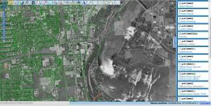
The Falls Viewer (located on a separate domain – fallsviewer.ca) is a simple to use online mapping application that allows users to create customized maps of Niagara Falls using a wide range of provided data sets. They provide the option of using either a base map background or using a black and white orthophoto.
There are custom tools that allow you to add text and draw features, a select tool for selecting features in existing layers, a buffer tool, measure tool and many more. You have the ability to print your custom map or use the permalink option to generate a custom link to the map you have created, to share with others or to come back to in the future. They also provide plenty of useful help in the form of FAQ and video tutorials.
There were a few things that I didn’t like about the online viewer, I couldn’t figure out how to change any of the color of the layers , there was no option to export data from the viewers or import other data sets. However other then that it contained just about everything that you would come to expect from an IMS, therefor thumbs up to the efforts of the Information Systems division for implementing a great little web mapping application for the City of Falls.
There are several downloadable Pre Made Maps of Niagara Falls for those that need a map quickly or are not interested in making their own customized maps. And for us GIS users who have access to GIS software applications, they have also a open data catalog with a multitude of data sets available in UTM Zone 17N, NAD 83 (see the Open Data FAQ for more details on the terms of use).
So it is pretty obvious that the GIS folks at the City of Niagara Falls have done a great job with their efforts of supporting open government initiatives by providing Canadians with data sets to use in their own GIS software applications and also for providing the Falls Viewer for those that do not have access to GIS software. If you have a need for data in the Niagara Falls region or just want to play around with available data sets then I recommend that you take some time and check out the data sets and applications provided.
For more information about the Open Data initiative, refer to their FAQ section, the Terms and Conditions or contact them directly ([email protected]) with your questions, concerns or input. They have mentioned that would love to have your input and feedback in order to continue providing great information and services .
[image sources: niagarafalls.ca]

