Only a hill: earth set a little higher
Above the face of the earth: a larger view
Of little fields and roads: a little nigher
To clouds and silence: what is it to you?
Only a hill: but all of life to me,
Up there, between the sunset and the sea.
- Geoffrey Winthrop Young
To really know a mountain you need to experience it through the seasons and in different shades of light, not just during the day but at dawn or dusk or even at night when its mood is at its wildest and most dynamic. It can also be more peaceful. You might be the only one there, with only the wind, rocks and millions of stars for company. In the case of Mount Brandon, an Atlantic hill on the northern fringes of the Dingle Peninsula, you’ll also hear the sound of the sea. At dawn or dusk and at night, the mountain delivers a more spiritual experience, and when you compare it to any other time of day, can be immensely gratifying. Perhaps this is how the Irish saint Brendan felt all those centuries ago when he meditated on the summit before leaving on his epic voyage to Greenland and America.
St Brendan would have also gazed out to sea on his many daytime visits. The blue Atlantic is an inviting feature, it draws you into a mood of contemplation but at the same time can be a symbol of curiosity as the mind wonders, ‘what of the land on the other side?’. Perhaps St Brendan did and this filled him with a desire so overpowering he was convinced to set sail in a tiny curragh from Brandon Creek with a band of pilgrims, to seek out this Promised Land. And so it came to pass that the mountain was named after him, for Cnoc Bréanainn or Mount Brandon (952m/3,123ft), is recorded as an entry for AD1063 in the Annals of the Four Masters. Today, along with Croagh Patrick it is considered as one of the ‘holy’ mountains in Ireland due to its connection with an Irish Saint.
There are a few ways to make it to the top of Mount Brandon. One popular route is from Faha on its eastern side. You can also get at it from the north from Masatiompan, or the south from the top of the Connor Pass. However, the easiest way up is to follow the signposts of a well-established pilgrim route known locally as Cosán na Naomh (meaning ‘Path of the Saints’), which now culminates on the summit of Mount Brandon. Measuring around 18km (11 miles) in length, Cosán na Naomh connects many of the early Christian sites on the Dingle Peninsula from its town to Mount Brandon via Ventry, An Riasc and Kilmalkedar Church.

Start and Finish
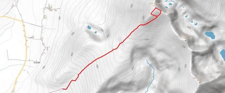
This 7km (4¼ miles) out-and-back route follows the signposts of Cosán na Naomh to the summit from its gentler western side via the Stations of the Cross. Start (and finish) at a large car-park (Grid Reference Q 434 094) at the end of a cul-de-sac signposted ‘Mt.Brandon’ on the west side of the mountain in An Baile Breac, just off the R549. Although there are a good few places for parking here, do plan to arrive early, especially at weekends or public holidays, when it might fill up quickly.

In The Footsteps Of Saints
The route to the summit of Mount Brandon is signposted throughout. At the far end of the car-park, cross a bridge over a stream and follow the track uphill. Keep the stream to the left and continue to a metal gate. Use the kissing gate there to soon veer left and away from the track and follow (white) wooden posts which leads you back toward the stream. Cross the stream then walk to a pile of rocks with a wooden cross in the center (Grid Reference Q 439 099).
Now, with the stream to your right, follow the wooden posts uphill on a grassy path to another pile of rocks marked by a cross – this is the First Station on the Cosán na Naomh. The track passes two other Stations, becomes peaty and stony until reaching a standing stone beside a white post near the Fourth Station. After this, the track becomes even stonier with the slope ever-steepening before the next Station. After this the ground relents to reach a standing stone on a rocky mound before the Sixth Station. The trail progresses uphill from here, charting its way along a further eight Stations. It passes an area of rocky outcrops, winds along the side of a spur and then meets a wall before the final pull up to Mount Brandon. There’s a cairn, trig pillar and a cross on a pile of rock to mark the summit. It is also said that the remains of St Brendan’s oratory and a holy well was once here.
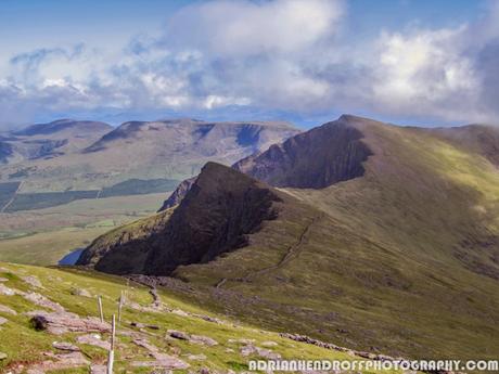
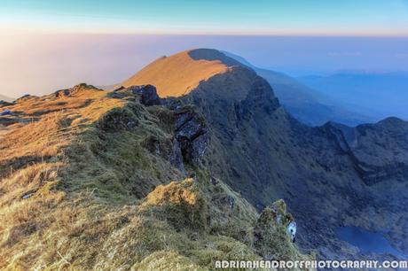
The summit decorations will only steal you a momentary glance but your eyes will now be drawn to the majestic surrounds. You’ll feel like you’re in heaven, for this is the mother of all mountain panoramas in Ireland. Brandon Bay curves into a cluster of hills in the distance, its stature beaten only by the razor-sharp tail-end of the Faha Ridge that soars up to Brandon’s elevated heights. Then to the west there’s the intricate Dingle coastline stretching from Smerwick Harbour to The Three Sisters, dotted by offshore islands that includes the Great Blasket. Finally to the southeast, cast your eye along the Brandon ridge itself which extends like an elongated prehistoric creature with sharp, angular fins. Reserve this for a clear day and you’ll not want to leave, it’s that good.

Stay Safe
The summit of Mount Brandon is around 800m (2625 feet) higher than the start. Due to its proximity to the Atlantic, high winds and low cloud are common. It is not advisable to attempt this route in strong winds or gales. Its eastern flanks are incredibly steep so stay well away from cliff-edges while up on the ridge. The route’s an out-and-back, making navigation a case of retracing your steps but despite this bring a map and compass (and know how to use it). Wear good hiking trousers (no jeans) and even in the summer, bring along a warm hat and gloves. Also make sure you pack an extra fleece layer and waterproofs just in case it rains. You’ll need good boots to do this hike, ideally 3-4 season ones with good ankle support. Carry a headtorch, a packed lunch and sufficient liquids to drink. Bring along a fully charged mobile phone and if you have to call for Mountain Rescue ring 999 or 112.
Forecasting the weather
The temperature at the summit can be up to 8°C colder than at the start, and colder still if you add any wind-chill. The Kerry weather is influenced by changeable Atlantic weather systems, so check the forecast on the morning of your walk and be equipped for all conditions. Forecasting the weather is a bit of a specialist subject for me. I’ve come up with the knack of getting the forecast nailed over the years – as a photographer who climbs I need the conditions spot on to come away with the best images. My advice is to use yr.no – use the website not the App and always look at the latest update. Look up ‘Brandon Mountain’ there and dive into the detailed, hour-by-hour forecast – this gives you all the important information like cloud cover, the wind-chill factor, precipitation and wind speeds. Apart from yr.no, the met.ie Rainfall Radar and Atlantic Charts are also useful.
About The Blogger
Adrian Hendroff is a member of the Outdoor Writers & Photographer’s Guild and a Mountaineering Ireland approved course provider. He is a fully-insured mountain guide and runs regular navigation and Mountain Skills courses. Adrian has written several Irish walking guidebooks for the Collins Press and is a regular contributor to newspaper/magazine features. He also runs outdoor photography workshops. More on Adrian see www.adrianhendroff.com or www.fabulousviewpoints.com
