Over the past decade Real Time Kinematic (RTK) surveying with Global Navigation Satellite Systems (GNSS) has become common practice in geomatics.
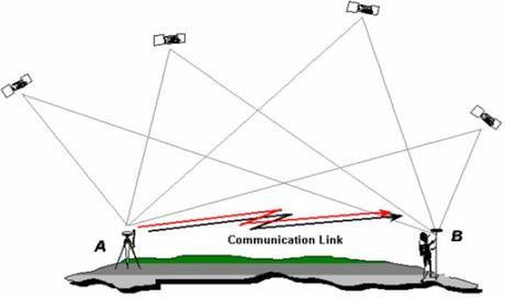
RTK surveying is a relative positioning technique which measures positions using two GNSS antennas in real time. One is setup on a static point with fixed coordinates and is known as the base station. It uses a high frequency radio to transmit its raw observations to the second unit (known as the rover) and then the rover uses both observations to compute a position relative to the base location in real-time. RTK surveying requires reliable communication between base and rover units and works best with short baselines as the precision of RTK measurements decreases as the baseline length increases.
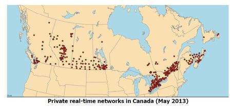
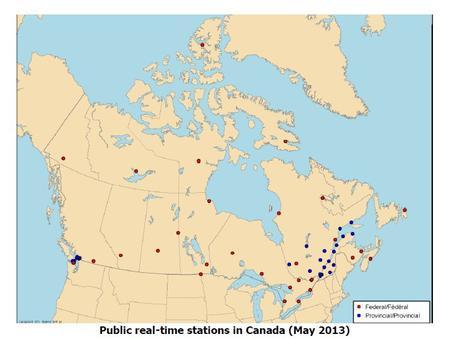
Real Time Networks have been developed as a method of extending range limitations between base-to-rover. RTNs make use of a several base stations together to collect GNSS observations that can be used with a rover to compute a position relative to the network solution in real-time. During the last few years more public and private RTNs have been rapidly increasing, providing larger coverage zones (mostly in higher populated regions). However due to the size of Canada and the availability and extent of RTN zones, RTK surveying remains to be the viable option in GPS surveying.

Both RTK & RTN GNSS surveying can allow people to achieve relative positioning with centimeter (cm) precision, however there are several important factors that need to be considered and thus a need for a good guide of best practices (equipment calibration, errors, multipath, geometry, etc.). Therefore Natural Resources Canada (NRCan) put together a group of exports from various departments that came together to publish a new set of guidelines for RTK / RTN GNSS surveying in Canada in order to better assist the surveying community and the growing geomatics industry in Canada. Their goal was to provide the industry with a set of concise and easy to follow best practice guidelines that when followed can help users achieve centimeter level RTK/RTN survey accuracy.
You can download the 29 page PDF document with this link
http://webapp.geod.nrcan.gc.ca/geod/publications/pdf/Canada%20RTK_UserGuide_v1%201_EN.pdf

Post Update: Since publishing this info last year, I have come across some other similar documents about RTK GNSS surveying from various other sources and have included the links to them below.
- https://www.ngs.noaa.gov/PUBS_LIB/NGSRealTimeUserGuidelines.v2.1.pdf
- http://www.sssi.org.au/userfiles/docs/QLD%20Region/documents_1342665635458677117.pdf
- http://archive.ilmb.gov.bc.ca/crgb/gsr/documents/BCGuidelinesForRTKGPSSurveys.pdf
- http://www.fig.net/pub/fig2007/papers/ts_2b/ts02b_01_wu_etal_1330.pdf
April 7, 2015 | CanadianGIS Tags: Canada, GNSS, GNSS antennas, GPS surveying, raw observation, Real Time Kinematic, Real Time Networks, RTK, RTK surveying
Leave a Reply Cancel reply
You must be logged in to post a comment.

