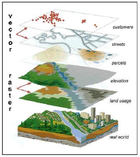
Geomatics has become a pretty common term in Canada lately and includes many different disciplines such as geographic information systems (GIS), remote sensing, cartography, land surveying, global navigation satellite systems (GNSS), photogrammetry, geography and other related forms of spatial mapping. Using acronyms and abbreviations is commonly practiced in the Geomatics industry and most of the time people just assume that everybody else knows what every acronyms and abbreviation stands for. Well that is obviously not the case most of the time and over the years I have created myself a little digital cheat-sheet of geomatics acronyms and abbreviations that I use with my work in my writing.
Below is the collection of common acronyms and abbreviations that you may find in the Canadian Geomatics industry (GIS, GPS, remote sensing, cartography, geography, surveying, Government etc.). If anybody knows of any key ones that missing off of this little Geomatics Acronyms and Abbreviations cheat-sheet then let us know and we will gladly add them to the list.
[page updated May 2014 - The list is now over 300, thanks to many people who continue to send us more Geomatics Acronyms and Abbreviations not on the list.]
3D Three Dimensional

BCIT British Columbia Institute of Technology
BLDG Building
BM Bench mark

EC Environment Canada
ECRF Earth Centered Reference Frame
ENVISAT Environmental Satellite
EO Earth observation
EOF End of File
EOSAT Earth Observation Satellite
EOT End of Text
ERDAS Earth Resources Data Analysis System
ERS Earth Remote Sensing Satellite
ESRI (Esri) Environmental Systems Research Institute
ETM Enhanced Thematic Mapper
JP2 JPEG2000
JRSS Japanese remote sensing satellite
KB Kilobyte

KBPS Kilobytes per second
KGPS Kinematic GPS
kHz Kilohertz
km Kilometer
QA Quality assurance
QA/QC Quality assurance/quality control
QC Quality control
QGIS Quantum GIS
QS Quadratic splines
TBD To be determined
TC Transport Canada
TGO Trimble Geomatics Office
TIFF Tagged Image File Format
VGI Volunteered Geographic Information
WMF Windows Metafile Format
WWW World Wide Web
W3C World Wide Web Consortium
WYSIWYG What you see is what you get
XML eXtensible Markup Language
-
March 8, 2013 | tmackinnon
