GeoAlliance Canada Receives Funding to Promote Use of Geospatial Data and Tools
Dec 14, 2015 – Today the Canadian geospatial community received a significant economic thanks to a new funding contribution agreement with Natural Resources Canada. GeoAlliance Canada, a national non-profit umbrella type organization launched earlier this year, received the funding in support of a new mandate to provide essential leadership within the geomatics sector and the geospatial community.
Through the engagement of key groups and organizations, GeoAlliance Canada has begun to articulate and promote the benefits of using geospatial data and tools for effective decision making to leaders within business, government and education circles. The contribution funding from Natural Resources Canada will have an immediate impact by providing essential operational resources for this fledgling non-profit organization.
For more information about GeoAlliance Canada or this contribution funding agreement to Promote Use of Geospatial Data and Tools, please contact us.
By canadiangisFiled in: Geo Industry NewsTags: geospatial community, Geospatial data, Natural Resources Canada, tools, GeoAlliance Canada, Funding
Also Check Out ...

TeachMeGIS, a Houston based GIS training company, has recently announced a decision to expand its public petroleum based GIS training classes to Calgary, Canada. This expansion has been expedited by the growing demand for geospatial skills in the industry.

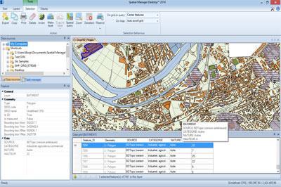
Spatial Manager Desktop™ is a desktop application designed to manage spatial data in a simple, fast and inexpensive way. Developed by a group of professionals working in the areas of GIS, Planning, Infrastructure and Civil Engineering, it provides the user with powerful tools to address the most common tasks of management and operation in the world of spatial information

Esri Canada marks 30 years of operations this year with a continued commitment to provide innovative enterprise geographic information system (GIS) solutions based on Esri’s ArcGIS platform. ArcGIS has evolved from a niche technology for mapping professionals into an open, pervasive Web GIS platform that everyone can use.
Online Toronto Historic Maps comparison tool

