Free & Open LiDAR Data Sources in Canada
LiDAR (Light Detection and Ranging) is a remote sensing technology that many people consider to be relatively new (to find out more about about LiDAR including history, uses and the technology behind it … click here).
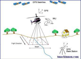
However the use of LiDAR in geomatics dates back to the 1980s when the deployment of Global Positioning Systems (GPS) combined with inertial measurement units (IMU) allowed precise positioning of aircraft, provided the ability for airborne LiDAR surveying. So although it is not actually new technology it has recently become more common in geospatial related projects over the past few years.
LiDAR data can be pretty expensive, therefore is often not available in most open data catalogues. However times are changing, thanks to continuous improved technology, combined with increased supply and demand from the geospatial user community, we are starting to see more and more LiDAR data sets made available to the general public.
Since starting our Open Data Resources list in 2010, we have received thousands of requests to help people find various Canadian data to use with their geospatial projects. And in that time have started an unofficial list of places where LiDAR data that is available for the public to use.
Today we are making our list available to our readers in the hopes that more people can make use if this data and that the geospatial community might help add more sources to it.
We plan to continue update this list as we learn about more data and hope that if anyone knows of other free LiDAR data sources that we have missed then they will let us know so we can make those sources available to others.
Below are some of the many places on the web that provide free LiDAR data downloads …
Alberta LiDAR Data
County of Grande Prairie, Alberta – http://www.countygp.ab.ca/EN/main/community/maps-gis/open-data/data.html
Fort McMurray, Alberta – http://opendataareas.ca/data/products/fort-mcmurray/lidar-3/?_sft_product-region=fort-mcmurray
Beaver Hills, Alberta – http://opendataareas.ca/data/products/beaver-hills/lidar/?_sft_product-region=beaver-hills
Taber, Alberta – http://opendataareas.ca/data/products/taber/lidar-5/?_sft_product-region=taber
Utikuma Lake, Alberta – http://opendataareas.ca/data/products/utikuma-lake/data-from-airborne-6/?_sft_product-region=utikuma-lake
Fox Creek, Alberta – http://opendataareas.ca/data/products/fox-creek/lidar-4/?_sft_product-region=fox-creek
RMH-Sylvan, Alberta – http://opendataareas.ca/data/products/rmh-sylvan/lidar-2/?_sft_product-region=rmh-sylvan
British Columbia LiDAR Data
Surrey, British Columbia – http://www.surrey.ca/city-services/13893.aspx
Vancouver, British Columbia – http://data.vancouver.ca/datacatalogue/LiDAR2013.htm
Upper Columbia River Basin East, British Columbia – http://opentopo.sdsc.edu/lidarDataset?opentopoID=OTLAS.032012.26911.1&minX=-119.743&minY=49.033&maxX=-119.243&maxY=49.385
Manitoba LiDAR Data
La Salle watershed, Manitoba (southern Manitoba) – http://open.canada.ca/data/en/dataset/5aa09916-130f-4747-847e-23e6728c04e3
New Brunswick LiDAR Data

City of Saint John, New Brunswick http://www.saintjohn.ca/en/home/cityhall/financeadmin/informationtechnology/opendata_catalogue/dataset_LiDAR.aspx
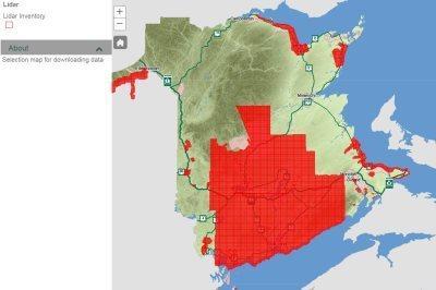
Various places in NewBrunswick (almost half of the Province) – The Province of New Brunswick has extensive LiDAR coverage covering almost 40% of New Brunswick and recently decided to release nearly 30,000 square km of that LiDAR data free for public use (as well as all future LiDAR collected by the Province).
The LiDAR data is available from the GeoNB Data Catalogue and both an online map application and a Google Earth index file have been provided to help find the areas that currently have data available. http://geonb.snb.ca/downloads/lidar_index/geonb_li-idl_kml.zip
Nova Scotia LiDAR Data
Halifax, Nova Scotia – offers digital elevation model (DEM) & digital surface model (DSM) created from LiDAR data http://www.halifax.ca/opendata/files/
Various places in Nova Scotia – (currently includes Antigonish, Eskasoni, Hantsport, Shelburne, New Glasgow, Pictou County, and Lockeport with more areas becoming available soon via a new lidar download tool) https://data.novascotia.ca/browse?q=LIDAR
Ontario LiDAR Data
Toronto, Ontario – http://maps.library.utoronto.ca/cgi-bin/datainventory.pl?idnum=1083&display=full&title=Toronto+Lidar+Data+
Quebec LiDAR Data
Montreal, Quebec – LiDAR data collected in 2015 that covers the Island of Montreal and surrounding area is available from Montreal’s open data portal https://www.donneesquebec.ca/recherche/fr/dataset/vmtl-lidar-aerien-2015
Saskatchewan LiDAR Data
Swift Current, , Saskatchewan – http://open.canada.ca/data/en/dataset/9bdc1a9c-baf7-4eb0-a532-c1057b284b8f
Various places in Saskatchewan – http://open.canada.ca/data/en/dataset/c495dc2b-6988-4d1f-a6a4-6db4ac14c311
Share:

