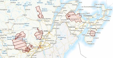
Natural Resources Canada recently added a new data layer to the Federal Government Open Data portal to help with emergency management (particularly for flood and earthquake risk analysis).
The data layer consists of delineated building footprints with height and elevations automatically extracted from airborne LiDAR data, high-resolution optical imagery or other sources.

The data set available in vector format contains close to 1 million building footprints in several different geographies across the county. Some of the areas with data that are currently available include:
* Alberta: Airdrie
* British Columbia: Burnaby, Surrey, Vancouver
* Manitoba: Assiniboine_River, Cooks Creek, Jackhead, Lake Manitoba, Roseau River Watershed, Seine Rat River
* New Brunswick: North Eastern New Brunswick
* Nova Scotia: Lunenburg County
* Quebec: Pontiac, Val des Bois, Gateneau, Mauricie Nord et Sud, MONTREAL and many more areas of Quebec
Natural Resources Canada plans to continue to expand this coverage as more LiDAR data sets become available to extract building footprints from.
You can access Automatically Extracted Buildings data and documentation from the Canadian Open Government Portal in WMS, FGDB and Shapefiles formats. https://candiangeo.info/Extracted_Buildings
Click here to discover Free and Open Data from all regions of Canada
