Do you know about the trail that links the East Bay Regional Parks? Have you run it? If so, what is/are the best section(s)?
- Fellow East Bay runner (and now marathoner) Jen
Continuing on with my two-day goal of mapping a 32-mile course from Wildcat Canyon to Chabot Regional…
DAY TWO (TILDEN TO CHABOT):
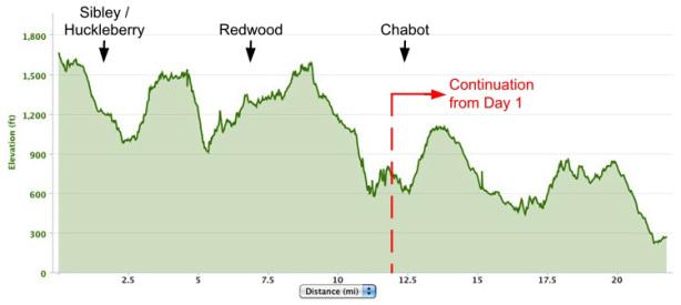
Arrows signify the boundary where each Regional Park/Preserve begins
Day Two of my East Bay trail hazing adventure would begin at the 12-mile mark of last week’s run, in the parking lot of the Tilden Park Steam Trains. Katie dropped me off amid the teeming masses of frazzled parents and unruly kids, and with full energy reserves I crossed Lomas Contadas and picked up the Bay Area Ridge Trail headed toward Sibley. The next 11 miles passed uneventfully, and roughly two hours later I found myself back in Redwood Regional on the West Ridge Trail, looking for the turnoff to the Golden Spike Trail.
There are two distinct ways to access the Golden Spike Trail. The first is the route I took the previous weekend to finish my run: follow the West Ridge Trail downhill to its end, cut a hard right on to the Golden Spike Trail, then follow it back uphill (sound fun yet?) and continue on your way. I prefer the alternative route, though it can be a bit tricky because there’s no sign indicating the turnoff for the Golden Spike Trail. Here it is: just before the West Ridge Trail takes a sharp left turn and begins its final steep descent, look for a “no bicycles” sign (i.e. a bicycle with a red diagonal line through it; see below) on the right side of the trail. This sign acts as gatekeeper to a short-lived (~20yds long), easy-to-miss rocky connector path leading to the Golden Spike Trail.
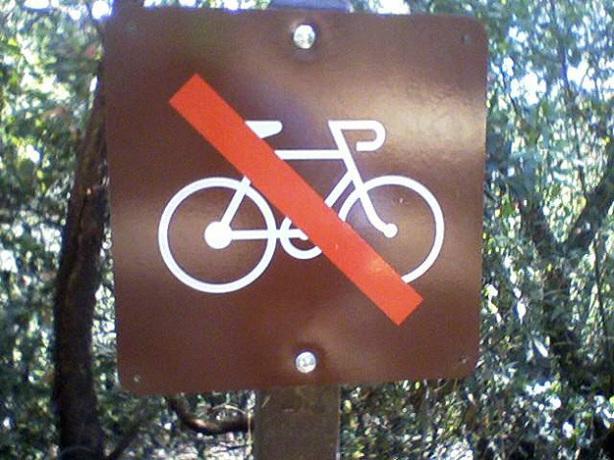
Like Platform 9¾ at King’s Cross Station, this sign conceals the connector path to the Golden Spike Trail
After less than ¾-mile on the Golden Spike Trail, look for the sign indicating the turnoff to Redwood Road. If you reach the intersection with the Toyon Trail, you’ve gone too far. Follow this sign out to and across Redwood Road to the Big Bear Staging Area parking lot, and voilà! You’ve just entered Anthony Chabot Regional Park. Based on my own experience, Katie will be waiting here with a smile and a bottle of ice-cold coconut water. Not easy to run away from, and yet I did…
Straight into the arms of the MacDonald Trail (doubling as the Bay Area Ridge Trail) and another steep ascent. Another feature currently missing from Google Maps is the MacDonald trailhead, which begins on the left side of the Big Bear Staging Area parking lot and runs parallel to Redwood Road a short distance before passing the MacDonald Staging Area. From there, the ~500ft of vertical gain over the next mile dragged a lot out of me, including some choice profanity, and I was relieved when the next 3+ miles into Chabot Regional were largely downhill.
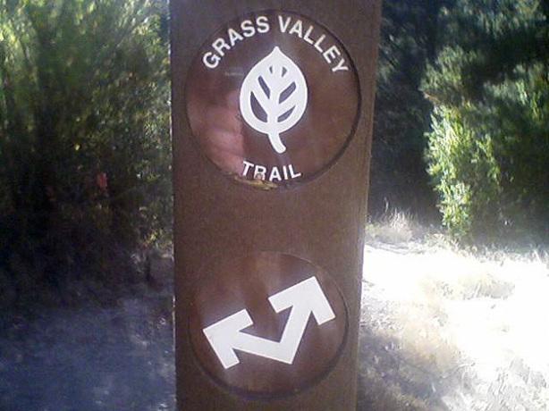
Choose your own adventure (I chose left) at the junction of the MacDonald Trail and Grass Valley Trail
After ~2.75 miles the MacDonald Trail hooks up via a short connector trail with the Grass Valley Trail. Here a two-arrowed sign (see above) gives you the option to either forge straight ahead, or swing a switchback turn to your left and continue along the unlabeled Bay Area Ridge Trail. Take the left turn, and you’ll descend through a gate and past the Bort Meadow Staging Area, where the trail widens on its way into Chabot Regional.
The Grass Valley Trail is relatively flat and mostly exposed, though to a lesser extent than Nimitz Way. My late-afternoon run benefitted from extensive shading, courtesy of the densely packed trees lining the western (right) side of the trail.
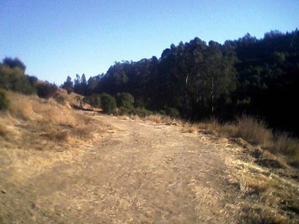
Now that thar’s a trail! The comfortably wide Grass Valley Trail, to be exact
Within 2 miles the Grass Valley Trail morphs into the Brandon Trail, another heavily used footpath that leads through Chabot Regional and to this day’s finish line ~5 miles away. After ascending 300ft in half a mile, the Brandon Trail undulates gently for ~2 miles before starting, like moth toward bug zapper, its inexorable downward trajectory toward Redwood Road. You’ll see your final destination sprawling below (far below, it seemed to me), before the bottom drops out and the trail descends 600 vertical feet in 1.5 miles, taking back in short order all the elevation (and then some) you’ve gained to that point.
Somewhere along this descent – I didn’t notice where – the trail splits into two separate forks of the Bay Area Ridge Trail, one of which deviates eastward along the Willow View Trail toward the Chabot Staging Area and the East Bay Municipal Utility District (EBMUD). Unless you want to take a detour toward the enticingly named EBMUD, continue down the Brandon Trail which bottoms (and flattens) out at the Willow Park Public Golf Course. Stay on the trail bordering the golf course, hopping or sidestepping the occasional log neatly placed across the trail, and that’ll be Redwood Road to your left. Continuing along the Brandon Trail parallel to Redwood Road, I reached the Proctor Staging Area where this branch of the Bay Area Ridge Trail ends. Not with a bang, but a whimper.
After 45 miles of blood, sweat and tears eyeball sweat on some of the Bay Area’s toughest trails, I could relate.
WANT MORE? To continue on from the Proctor Staging Area to the Lake Chabot Marina, follow the signs for the Lake Chabot Bicycle Loop and Ten Hills Trail south to the McGregor-George Trail; from this junction it’s less than a mile to the marina.
GEAR: For Day One of my East Bay trail tour I wore my Brooks PureCadence shoes (with 5mm heel-to-toe drop), which despite their road tread didn’t disappoint on the dirt. For Day Two I relied on my zero-drop Merrell Road Gloves, with predictably solid results: the well-worn Road Gloves continue to ride comfortably up and down hills and on all terrain. I appreciated their lightweight build and consistent traction, without ever lamenting their lack of a protective rock plate.
FINAL STATS:
Total distance: 21.8 miles (including planned and unplanned detours)
Total time: 4:00:43
Average pace: 11:03/mile (miles 15 and 21 @ sub-10:00/mile)
Elevation change (Garmin Connect Software): 3,277ft ascent, 4,665ft descent
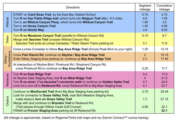
Complete directions for my two-day East Bay trail adventure
