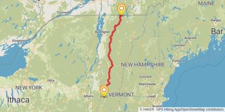
Stretching 272 miles from the Massachusetts-Vermont border to the Canadian border, the Long Trail is one of the most iconic hiking trails in the United States. Planning your Long Trail thru-hike is simple with HiiKER. And in this guide, we’ll help you get ready for an adventure of a lifetime!
History of the Vermont Long Trail
The Vermont Long Trail was first conceived in 1909 by James P Taylor and since its opening in 1930 it holds the title as the oldest long-distance trail in the United States.

During its construction, Benton MacKaye – a forester and conservationist first conceived the idea of an Appalachian Trail. To this date, both of these trails share about 100 miles of a footbed through the Green Mountain wilderness.
Planning Your Hike

Here are some of the frequently asked questions when planning a thru-hike of the Long trail.
When is the best time to Hike the Long Trail?
The best time to hike the trail is from late spring to early fall. Be aware that the trail can be muddy in spring and early summer, and the weather can be unpredictable at any time.
Where can I resupply on the Long trail?
There are several towns along the trail where you can resupply. Plan your itinerary carefully to ensure you have enough food and supplies between these points. You can see all the towns and stores that are long the trail with HiiKER. We have also listed some of the key resupply points further down in this guide.
Where can I camp on the Long trail?
Tillotson Camp on the Long trailThere are over 70 shelters and campsites along the trail. These are available on a first-come, first-served basis. You can find listings of these shelters and campsites on HiiKER.
Do I need a permit to hike the Long trail?
No permits are required to hike the trail, but you are expected to be a responsible hiker and to follow Leave No Trace principles.
What to Pack for Hiking the Vermont Long Trail
Packing for a long-distance hike like the Long Trail requires careful consideration. You need to strike a balance between carrying all the essentials and keeping your backpack as light as possible. Here are some crucial items you should include in your packing list:
- A Backpack: Backpacks come in all shapes and sizes. Many ultralight backpacks are great for shedding unnecessary weight. But this might not be the best option for everyone. The most important thing here is comfort and weight distribution. Tip: The bigger the bag, the more stuff you pack it with.
- A lightweight tent: While there are many accommodation options along the trail, it’s always wise to pack a tent for times where you might need it. Like backpacks, there are many ultralight options to save carrying too much weight.
- Sleeping bag and sleeping pad: Whether you’re staying in a shelter or camping, staying warm at night is essential. Make sure you pack the right sleep system for the time of year.
- Clothing: Quick-drying clothing is key. This should include moisture-wicking base layers, insulating mid-layers, and a waterproof outer layer. Avoid cotton where possible. Don’t forget a hat and gloves. Pack enough socks and underwear for comfort, but remember that you can wash items on the trail.
- Footwear: Trail runners are great for long distance hiking. Some of these are not waterproof but do drain water quickly. Waterproof is advisable, especially if you will be hiking longer distances between places to dry them.
- Cooking Equipment: A lightweight stove, fuel, a pot, a spoon, and a lightweight, durable food container.
- Food and Water: High-calorie, lightweight food is best. Plan your meals and snacks according to your resupply points. Bring a water bottle and a reliable water treatment method.
- First Aid and Hygiene: A basic first aid kit, personal medications, sunscreen, bug spray, toilet paper, and a lightweight trowel for digging cat holes.
- Navigation: With the HiiKER app, you can download trail maps for offline use, making navigation easier and more reliable. However, it is wise to bring a compass, and physical maps as a backup. With HiiKER PRO+ you can print stages of the Long Trail with your home printer.
- Emergency Items: A whistle, a headlamp with extra batteries, a multi-tool, and a lightweight emergency blanket.
- Miscellaneous: Don’t forget items like sunglasses, a durable trash bag (pack out all your trash), a compact camera or smartphone for photos, and a lightweight book or journal for downtime.
Remember, every hiker’s needs and preferences vary, so consider this list as a starting point and customize it according to your needs. Always double-check your gear before setting off, and remember to pack the most important item of all: a sense of adventure!
Resupply Points along the Long Trail
Resupplying is a crucial part of any long-distance hike, and the Long Trail offers several towns and points where you can replenish your supplies. Here are some key resupply points:
- North Adams, MA: Located just south of the start of the Long Trail, North Adams is an excellent place to make any last-minute purchases before you start your hike.
- Manchester Center, VT: About 60 miles into the trail, Manchester Center is a hiker-friendly town with a variety of stores for resupplying, including a large grocery store and an outdoor gear shop.
- Rutland, VT: Located about halfway through the trail, Rutland has a bus service that can take you into town where you’ll find several grocery stores, outdoor gear shops, and a laundromat.
- Killington, VT: Just north of Rutland, Killington is another good resupply point. There’s a post office where you can send yourself a package, and a general store for other supplies.
- Waitsfield, VT: About 170 miles into the trail, Waitsfield is a bit off the trail, but a hitch into town will bring you to a variety of resupply options.
- Waterbury, VT: A few days north of Waitsfield, Waterbury offers a grocery store and other amenities. The town is a short hitch west of the trail.
- Stowe, VT: Located off the trail, but accessible by hitchhiking or bus, Stowe is a popular resort town with full services, including several grocery stores, restaurants, and an outdoor gear shop.
- Johnson, VT: This small town offers limited resupply options, but there’s a grocery store where you can pick up basic supplies.
- Jeffersonville, VT: This is the last major resupply point before the Canadian border. It’s a bit off the trail, but the town offers a supermarket, a pharmacy, and a post office.
- North Troy, VT: Located at the northern terminus of the trail, North Troy is a small town with a few stores where you can grab a celebratory meal and replenish supplies before heading home.
Remember, while these towns and points offer resupply options, it’s always a good idea to carry enough food and supplies to last for a few days between resupply points. With careful planning and the help of the HiiKER app’s trail data, you can navigate your resupplies effectively on the Vermont Long Trail.
Hiking the Long Trail with HiiKER
HiiKER can significantly enhance your Long Trail experience. Here’s how:
- Trail Information: HiiKER provides comprehensive details about the Long Trail, helping you understand the terrain, length, difficulty level, and estimated completion time.
- Offline Maps: With HiiKER, you can download trail maps for offline use for FREE. This feature ensures you always have a reliable navigation tool, even in remote areas.
- Topographical maps: With HiiKER PRO+, you gain access to all the best maps available on the app. For the Long trail, the US Forestry services maps are particularly useful!
- Print maps: Rather than carrying a much larger map, you can print out individual stages of the trail with your home printer. saving money and weight!
- Tracking: Track your hike with HiiKER to understand your progress, and share your experiences with friends and the hiking community.

