Bright big Dallas
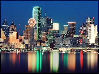
Locals say everything is bigger in Texas, and maybe no place exemplifies this boast more than Dallas – “Big D” – a booming metropolis of well over six million people spread over the flat north Texas grasslands [1]. Examples of bigness: the city is home to theworld’s largest domed stadium, along with one of the biggest and busiest airports, and many of the nation’s “mega-churches”. Fulfilling its reputation, metro Dallas has grown to become America’sfourth most populous urban area [2] and the nation’s sixth largest economy. An evening drive south along I-75 towards the city (inside an air-conditioned car which repels the smothering summer heat and humidity), reveals Dallas in all its vibrancy and excess. Starting around Allen, 25 miles or so from downtown, you enter into Dallas’ suburban sprawl: shopping malls, box stores, business parks, mid-rise towers, tract housing developments, and fast food restaurants flanking both sides of the freeway; your eyes dazzled by the sea of house lights, glowing colorful business signs, the pale orange twinge of sodium-streetlights, the alternating white-red of countless vehicle head-and tail-lights. Miles and miles later you can glimpse downtown, tall chromatically lit glass towers glinting in the fading twilight. It’s all new, pretty-ugly, dynamic-gaudy, impressive-bland, a 21st century American city.
What a contrast to the Dallas of my parents’ youth, then a quiet mid-size southern city made infamous by an assassination. Contrast the blandness of Dealey Plaza (which looks much the same as it did in 1963 [3]) with the glitzy modern hustle of the nearby downtown. Dallas is emblematic of what seems to be a continuing fact of America; it’s ever shifting, moving, resettling population. It’s a source of some amazement to me how fluid and dynamic the American people remain, after nearly two-and-a-half centuries of nationhood, in where they choose to live. I think this can be demonstrated by two graphics.
Where Americans Lived in 1950
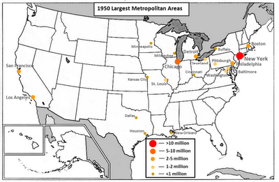
First, a map showing the largest urban areas in 1950:

In 1950 the U.S. population was 151 million, 6 percent of the world total. Well over a third of the population (36%) lived in rural areas, and as the map above shows, big cities were few and outside of the Northeast and Midwest, widely scattered. Just one city, New York, had more than 10 million people. Chicago, then still America’s “Second City”, was the only other city with more than 5 million people. Just five other places had more than 2 million: Los Angeles, Philadelphia, Detroit, Boston, and San Francisco. Only five others cities, St. Louis, Cleveland, Pittsburgh, Washington, and Baltimore had more than 1 million. The above map shows whole swathes of the country from the South, to the Mountain West, the Pacific Northwest, and desert Southwest bereft of large cities. Miami, Atlanta, Phoenix, Seattle, Denver, and San Diego didn’t even rank. Dallas and Houston were mid-size.
Largest Urban Areas in 1950
Rank City Metro Population Rank City Metro Population
1 New York 12,600,000 11 Washington, D.C. 1,287,000
2 Chicago 5,208,000 12 Baltimore 1,162,000
3 Los Angeles 4,250,000 13 Minneapolis 987,000
4 Philadelphia 3,297,000 14 Buffalo 895,000
5 Detroit 2,884,000 15 Dallas 855,000
6 Boston 2,301,000 16 Milwaukee 829,000
7 San Francisco 2,131,000 17 Cincinnati 813,000
8 St. Louis 1,541,000 18 Houston 701,000
9 Cleveland 1,425,000 19 Kansas City 698,000
10 Pittsburgh 1,400,000 20 New Orleans 660,000
Source: Peakbagger.com
In 1950 the most populous state was New York with a little less than 15 million people (10 percent of the nation’s total); more than double the population of Texas and five times more than Florida. Over half the American population lived in a contiguous band of 15 Midwest and Northeast states [4], which together comprise just 15 percent of the total national land area. These are the states that were (1) well-settled, they all were admitted to the Union before the Civil War, (2) were home to America’s largest industrial centers, which in 1950 accounted for nearly 30 percent of the American economy (e.g., Detroit and Pittsburgh), and (3) were not hampered by the segregationist and discriminatory policies that caused the American South to languish for more than a century after the Civil War [5].
The least populous state was Nevada with just 160,000 people, and less than 50,000 of those lived in and around the new city of Las Vegas. Keep in mind an alternative statistic, baseball in 1950, still then very much America’s most popular sport, didn’t field a Major League team west of St. Louis or south of Washington [6].
Where Americans Lived in 2010
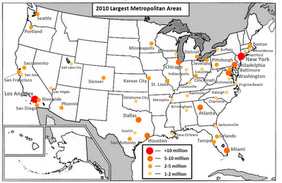
Now, a map showing the largest urban areas in 2010 (just sixty years – less than a lifetime – later):

The first thing that strikes you about this map is the impressive proliferation in the number of large cities. In 1950 there were 12 cities with metropolitan populations of 1 million or more, in 2010 there were 51. This is the result of two trends. First, by 2010 the U.S. population had more than doubled since 1950 to 308 million (5 percent of the world total) [7]. Second, the shift from rural areas to urban areas continued and in 2010, 82% of Americans lived in urban areas. So by 2010 there were more and bigger cities.
The next thing that strikes you is the blooming of large cities in the southern tier of the country. In 1950 the only “Sunbelt” city with more than 1 million people was Los Angeles. By 2010 this had drastically changed, as shown by the list of the 20 largest urban areas (Sunbelt cities highlighted in yellow) [8].
Largest Urban Areas in 2010
Rank City Metro Population Rank City Metro Population
1 New York 18,897,000 11 San Francisco 4,335,000
2 Los Angeles 12,829,000 12 Detroit 4,296,000
3 Chicago 9,462,000 13 Riverside 4,225,000
4 Dallas 6,372,000 14 Phoenix 4,193,000
5 Philadelphia 5,965,000 15 Seattle 3,440,000
6 Houston 5,947,000 16 Minneapolis 3,317,000
7 Washington, D.C. 5,582,000 17 San Diego 3,095,000
8 Miami 5,565,000 18 St. Louis 2,813,000
9 Atlanta 5,269,000 19 Tampa 2,783,000
10 Boston 4,552,000 20 Baltimore 2,710,000
Source: U.S. Census Bureau
Seven of these cities weren’t among the 20 largest metro areas in 1950 (Miami, Atlanta, Riverside, Phoenix, Seattle, San Diego, and Tampa). The largest states in 2010 were California with over 37 million people (12 percent of the nation’s people) followed by Texas at over 25 million. New York, by far the largest state in 1950, ranked third at over 19 million people, a position it will lose in the next year or two to Florida. Here’s a list of the ten largest states in 2010 along with their rank and population in 1950.
2010 1950
Rank State Population Rank Population
1 California 37,254,000 2 10,586,000
2 Texas 25,146,000 6 7,711,000
3 New York 19,378,000 1 14,830,000
4 Florida 18,801,000 20 2,771,000
5 Illinois 12,831,000 4 8,712,000
6 Pennsylvania 12,702,000 3 10,498,000
7 Ohio 11,537,000 5 7,947,000
8 Michigan 9,884,000 7 6,372,000
9 Georgia 9,688,000 13 3,445,000
10 North Carolina 9,535,000 10 4,062,000
Source: U.S. Census Bureau

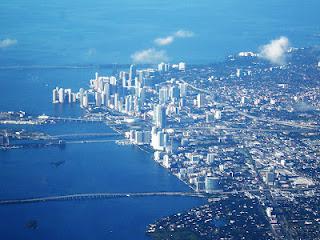
Miami, Florida, now one of the largest urban areas in the country
California, Texas, Florida, Georgia, and North Carolina have seen their populations more than double or triple, and in the case of Florida increase nearly seven-fold. Meanwhile the more established states in the Northeast and Midwest have seen far more modest growth, well below the overall U.S. population growth. Over the last sixty years Americans have chosen to live in the South and West. Why? I’ll offer some possible explanations:
- Economics. I started this post describing Dallas and its impressive growth in recent decades. Well, places like Dallas, Houston, and Atlanta have boomed because their economies are well-suited to the 21st century. Dallas is a hotbed for communications and electronics companies, Houston is the nation’s energy capital, and Atlanta is big in communications, transportation, and banking. A telling statistic: the city with the most Fortune 500 companies is unsurprisingly New York, but the next three are Houston, Dallas, and Atlanta (Charlotte, a banking center, is also in the top 10). Older cities like Buffalo, Detroit, Pittsburgh, and Cleveland where the economy was centered on heavy industry have struggled (or continue to struggle) to diversify their economies and keep up with the new dynamic cities in the South and West.
- It’s cheaper. An economist will tell you that a desired resource will be more expensive than an undesired one. This counts for real estate along with everything else. In the crowded cities if the Northeast, where population densities are high and development is extensive, real estate is expensive [9], especially relative to much of the less developed South and West. A few years ago I was amazed to see new three-bedroom single-family homes on sale only miles outside of downtown Houston starting at around $140,000. An equivalent house near my hometown of Baltimore would have been more than double that cost. And Baltimore is cheaper than places like Washington and New York. Cheaper housing and overall cheaper cost of living is hugely attractive. And people clearly have voted with their feet, moving to Atlanta, Dallas, Houston, Phoenix, Miami, Orlando, and other southern cities in the millions. Of course over time real estate will grow more expensive in these “new” cities as cheap land in those locations diminishes. In fact, the real estate markets in Florida, Las Vegas, and Phoenix were among the most affected when the real estate bubble burst in 2008. Massive demand had driven up prices to unsustainable levels. Maybe this is the first sign that the boom of the South and West will be tempered in the coming years.
- Air conditioning. Readers of this blog know that I think ubiquitous air-conditioning to be one of the fundamental technological revolutions of the last half century. I don’t care how attractive the economies or cost of living are, very few people would move to Phoenix or Las Vegas without the presence of air conditioning. The same is true to a certain extent with Florida and Texas. People like mild winters, which they get in the South, and air-conditioning ensures escape from the accompanying summer heat and humidity. This explanation for the American demographic shifts after World War II should not be overlooked.
- Transportation. Air travel and interstate highways connected all parts of the country in the decades after World War II. It became far easier to access far away places, far easier for companies to expand to new locations, and far easier for people to relocate - for whatever reason.
Americans like to think of themselves as exceptional, different from other peoples. One of the defining characteristics of America has been its centuries’ long movement across the North American continent; expanding, territorial-acquisition-by-territorial-acquisition[10], from the Atlantic seaboard all the way to the Pacific and beyond [11]. Surely the internal migrations since 1950 are part of American’s continuing evolution to settle their vast national expanse. But it’s also evidence that changing technology and economics have opened up the country in ways few could have expected in 1950. What will the national population map look like in sixty years time? What unexpected shifts will future demographers study [12]?
---
NOTES:
[1] Combined with its lesser twin, Fort Worth, in the commonly termed Dallas–Fort Worth Metroplex.
[2] That’s the fourth largest metropolitan statistical area (MSA) behind New York, Los Angeles, and Chicago. This is not to be confused with the larger combined statistical area(CSA), where Dallas-Fort Worth ranks seventh, behind NYC, LA, Chicago, Washington-Baltimore, Greater Boston, and the San Francisco Bay area.
[3] Kept much the same as a historic monument of course. And one must admit a rather eerie place to experience in person.
[4] Connecticut, D.C., Illinois, Indiana, Maryland, Massachusetts, Michigan, Minnesota, Missouri, New Jersey, New York, Ohio, Pennsylvania, Rhode Island, West Virginia, Wisconsin.
[5] This is a personal theory of mine, but it’s informed by history. The economy of the slave-dependent antebellum American South developed far more slowly than that of the free north prior to the Civil War. The South remained backwards through the century of Jim Crow following Reconstruction.
[6] It wasn’t until 1958 that Los Angeles got the Dodgers and San Francisco got the Giants (both relocated from New York).
[7] In the sixty years from 1950-2010 the world population more than doubled from 2.5 billion to 6.9 billion, a substantially higher rate of increase than the United States, itself a nation whose population grew (and continues to grow) much faster than the rest of the developed world.
[8] And this doesn’t count Washington and Baltimore as southern cities, which technically the Census Bureau does. Although as a resident of the Washington-Baltimore area, I can assure you that in neither culture nor weather are these cities truly southern.
[9] This remains true in relative terms even after the real estate bubble burst in 2007-08.
[10] A remarkable and seemingly unstoppable expansion from 1776 through nineteenth century that included glorious and shameful episodes.
[11] E.g., Alaska and Hawaii, several islands in the western Pacific, and for a short while, the Philippines.
[12] With a little luck (and good health) I’ll be around to witness it.

