Traditional images in geomatics are often two dimensional, meaning that all data in the image can be referenced by X and Y coordinates.

Three dimensional images (3D) incorporate a third dimension (the Z component) which represents the elevation or depth aspect of the data. To incorporate it into an image requires creating special geomatics value added products that allow users to perceive the presence of the third dimension into a traditional two dimensional setting (because most paper and computer screens are flat or two dimensional).
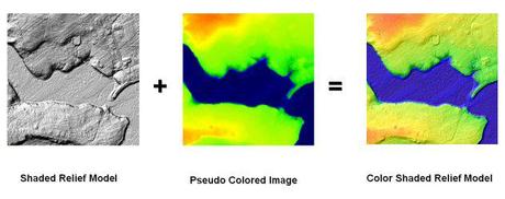
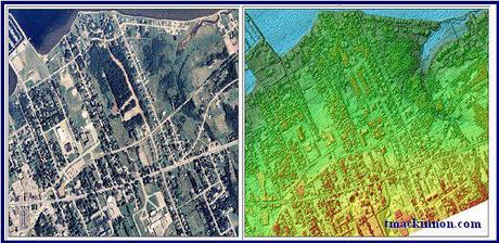
A color shaded relief (CSR) utilizes chromo stereoscopic techniques to help emphasize the depth of the Z dimension from traditional shaded relief models that already portray the presence of an elevation difference. Using carefully edited RGB (red, green, blue) pseudo colors and then encoding them into the shaded relief image provides the user with an even more enhanced feeling that they can perceive a third dimension from a two-dimensional medium (also helping to quickly decipher between high and low elevated regions). When a feature of the same color in the image is shaded darker than the shade of its background, then the background color will predominate in determining its perceived depth position in the image.

There are several different software packages that can be used to create CSR models, but I have found that Geomatica software by PCI Geomatics has proven to produce some of the better results in CSR models generated from DEMs. ChromaDepth 3-D glasses can often be used to further enhance the three dimensional feeling as well. These glasses use sophisticated micro-optics technology to transform color images into stereo 3-D. If you do not currently have PCI Geomatica then you can obtain a trial copy of it from their web site; then follow the steps outlined in the following CSR tutorial.
Here are some more Examples of some of the many color shaded relief (CSR) models that I have created

- Vancouver Island, British Columbia
- Gatineau foot hills of Quebec
- Irvine, California
- Cap Pele, New Brunswick
- Pointe Du Chene, New Brunswick
- Shediac, New Brunswick
- Bouctouche, New-Brunswick
- Makkovik, Labrador (Newfoundland)
- Antigonish, Nova Scotia
Color Shaded Relief related documents:
- Creating a Color Shaded Relief Model from a DEM with PCI Geomatica v9.1 software
- 3D Modeling with High Resolution LIDAR - presented at the GeoTec Conference in Toronto,Ontario and displayed at the Applied Geomatics Research Group in Middleton, Nova Scotia
- Bouctouche, NewBrunswick – Color Shaded Relief - presented at the CCAF annual general meeting held at the University of Moncton in Moncton, New Brunswick, and displayed at the Applied Geomatics Research Group in Middleton, Nova Scotia
- Flood Risk Mapping using LIDAR, SE NB Climate Change Action Fund - presented at Geomatics Atlantic 2004 Conference held at the University of New Brunswick in Fredricton, New Brunswick
- Integration of Digital elevation Models and Imagery : Terrain Analysis of the Antigonish Highlands - presented at the Center of Geographic Sciences in Lawrencetown, Nova Scotia
- Makkovik,Labrador – 3D modeling and Data Integration - presented at the Bedford Institute of Oceanography in Dartmouth, Nova Scotia
- Surface Modeling and LIDAR Validation
- Three Dimensional Flood Modeling with High Resolution LIDAR - (Graduate Project Final Paper) Middleton, Nova Scotia: Applied Geomatics Research Group, Centre
of Geographic Sciences, 200 pages - Three Dimensional Flood Modeling with High Resolution LIDAR presentation from the Canadian Institute of Geomatics 2005 Conference held in Ottawa,Ontario

