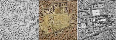
After spotting a tweet published by one Matt Guenoux, featuring an aerial timelapse of Roissy Charles-de-Gaulle airport taking shape based on pictures available on the fantastic IGN Remonter le Temps website, I thought it might be interesting to attempt something similar for Bordeaux, and quickly came up with the idea that the Mériadeck quarter would be the perfect subject matter!
So, here's the end-product, a 1-minute compilation of aerial photos stretching over a 95-year period that shows just how much the area has changed beyond recognition, from a grid of narrow streets and low-rise homes to the esplanades, walkways and office blocks of the urban jungle with which we are now familiar, and which Invisible Bordeaux documented in an article you'll find here. Enjoy the video, and if you scroll down a little further you can read about some of the things to look out for! (Although you might have to hit pause!)
Click here if video does not display properly on your device.
1924: The tight grid of narrow roads that made up the old, residential Mériadeck quarter, crossed from top to bottom by rue Dauphine, which later became rue Docteur-Charles-Nancel-Pénard (one of the streets that lead onto Place Gambetta). Among the sights clearly visible and that will remain so throughout the 95-year sequence: Chartreuse cemetery and Saint-Bruno church to the left, the Palais Rohan city hall and gardens to the right of the centre, Saint-André cathedral to the right, and the Palais de Justice law courts, bottom right.
1950: The focal point of the picture is still the square-shaped Place Mériadeck, a meeting point and hive of activity for locals.
1956: To the immediate north of Place Mériadeck, a square plot has been cleared to make way for the area's first high-rise building.
1961: The Résidence du Château d'Eau tower block has gone up. It turns out to be the only building to be completed from the original plans for the district.
1965-66: Further demolition work has cleared other plots close to Résidence du Château d'Eau. To the south, new modern extensions to the Ornano fire station are built (inaugurated December 1966).
1967-70: Far more space is cleared and the rectangular Post Office building has now appeared.
1973: Place Mériadeck is wiped off the map for good.
1976: The whole southern flank has become a building site, the first cross-shaped apartment and office blocks have appeared in the north-western corner, the circular, Guggenheim Museum-like Caisse d'Epargne building is beginning to take shape, and a huge chunk has been cut out of rue Docteur-Charles-Nancel-Pénard.
1979: New arrivals include the Mériadeck shopping center (which opened the following year), the Gironde préfecture building and, less visible from above, the Communauté Urbaine de Bordeaux block (now Bordeaux Métropole).
1980: Raised walkways between the different sections appear, further cross-shaped apartment blocks appear on the southern flank.
1984-85: The star- or flower-shaped Patinoire skating rink (and arena-circuit concert venue) emerges bottom left. The trees and water features of the central esplanade are clearly visible. A little further to the east, just to the north of Place Pey-Berland, the Saint-Christoly shopping center and apartment block is being built.
1989: The Lego-brick-like Aquitaine regional offices can be spotted over by Chartreuse cemetery, while the south-eastern corner of the area now boasts Novotel and Ibis hotels. A little further to the west, the municipal library has gone up.
1991-96: Opposite the library, the Conseil Départemental de la Gironde has installed its new premises. From this point onwards, most of the available space is occupied and new developments are few and far between.
1998-2000: The most notable addition to the area is the Richard Rogers-designed law courts over on Cours d'Albret.
2004: Nearby, Place Pey-Berland has been closed to road traffic to accommodate the new tram network and becomes fully pedestrianized.
2010-12: The Mériadeck effect extends to the north-east, as modern apartment blocks go up across the road from the La Poste building. Judged to have aged badly, the La Croix du Mail building is demolished and makes its way for the Cité Municipale, that can be seen in the 2019 GoogleEarth shot.
Of course, there is plenty more to spot. Do get in touch if Invisible Bordeaux has missed out on something, whether vital or trivial!
> Cet article est également disponible en français !
