


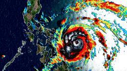
With typhoons or hurricanes, rapid intensification is an increase in maximum sustained winds of 35 mph (55 km / h) in 24 hours.
From Tuesday afternoon to Wednesday afternoon, Vongfong easily encountered this definition, going from a modest tropical storm with winds of 60 mph (95 km / h) to the equivalent of a major hurricane. Maximum sustained winds are now 120 mph (195 km / h) and the storm is still getting stronger.
This region of the world is no stranger to rapid intensification. Many storms experience rapid intensification each year due to the extremely hot temperatures of the sea surface.
But this is the first named storm of the season in the West Pacific.
It didn't exist until Tuesday, and now it will hammer the Philippines as the equivalent of a Category 3 or 4 storm on the Saffir-Simpson scale.
The impact of Vongfong
Weather models have struggled to predict Vongfong intensity, in part due to the small size of the storm.
Now that the storm has intensified so quickly, there is no doubt that it will be more than a rainmaker when it reaches the coast.
"Very heavy precipitation, damaging winds and strong storm surges are all major concerns with this storm," said CNN meteorologist Tom Sater.
"A silvery aspect, because it is a small storm, is that the strong winds of the typhoon extend only about 25 kilometers from the center."
While damaging winds will only occur along the immediate path of the storm, heavy rains will have a more widespread impact.
Rainfall amounts of 100 to 250 mm (four to 10 inches) will affect large areas of the Visayas and Bicol regions across northern Luzon.
Get your local forecast and weather news from around the world >>>Vongfong will pass just off Samar province on Thursday before making its first landing in the Bicol region, north of Legazpi on Thursday evening local time.
After hitting the Bicol region, the storm will retain most of its strength and move to the northeast of Luzon on Friday evening.
"It is possible that the center of the storm remains just offshore," said Sater. "It's not a big chance, but if the forecast moves just 50 kilometers east, it would keep the worst of the winds and storm surges offshore."
Typhoon seaso 2020 starts slowlynot
The typhoon season in the Western Pacific has no defined start and end like hurricane season in the Atlantic, as storms can form throughout the year.
While the peak of the typhoon season is late summer, there are often named storms in winter or early spring due to the warm waters of the Pacific.
This is the eighth start of the season since 1950, according to Colorado State University researcher Phil Klotzbach. The last time we had a subsequent start-up was in 2016, when the first named storm of the season did not arrive until the first week of July.
The Philippines is located in the main breeding areas of the tropical Pacific. On average, the region is affected by eight to nine storms.
Late seasons tend to be slightly quieter, but the evidence is weak, according to Klotzbach.
Source link