COLUMBIA — As Tropical Storm Debby headed into North Carolina, officials in South Carolina fanned out from the Midlands to the coast to assess the damage left in the storm’s wake so far.
That does not mean the storm’s impacts are over, as rivers will continue to rise, Gov. Henry McMaster reiterated Thursday afternoon.
Those of particular concern include the Little Pee Dee River near Galivants Ferry in Horry County, which is already flooding and could hit major flood levels Sunday afternoon. Also topping its banks is the Edisto River at Givhans Ferry in Dorchester County. It could keep rising until Tuesday, but the latest predictions from the National Weather Service have it staying just below major flood levels.
The Great Pee Dee River is also expected to flood. At Cheraw, it could crest early Sunday at moderate flood levels. But downstream, the waters will keep rising. Near U.S 301 east of Florence, the river is expected to be near the major flood stage next week.
“After the flooding is over, we will have a lot of cleaning up,” McMaster said at his fourth and possibly last public briefing on the storm.
There were still no reported fatalities or injuries as of Thursday afternoon. But the governor warned people not to relax too early.
“We want to remind everybody out there that it’s not over yet. We’re past some dangers, but there’s still plenty, so don’t let your guard down yet,” he said.
The storm hit Florida about 7 a.m. Monday and worked its way out to the Atlantic across Florida and Georgia.
Then it moved slowly up the South Carolina coast, dumping rain all the way, before making landfall again about 2 a.m. Thursday near Bulls Bay in northern Charleston Count, said John Quagliariello, a meteorologist with the National Weather Service.
As of Thursday afternoon, the storm was sitting on the border of South Carolina and North Carolina east of Charlotte, he said.
Employees of the South Carolina Emergency Management Division were assessing damage in nine counties on Thursday, said Director Kim Stenson.
Across Berkeley, Charleston and Colleton, 70 homes had some damage, including one destroyed and 15 with major damage, according to preliminary reports. In those three counties and Horry, 16 businesses also experienced some damage, Stenson said.
The heavy rain in the Pee Dee region and the Charlotte suburbs in York and Lancaster counties brought the total number of roads closed to 111 as of Thursday afternoon, said Transportation Secretary Justin Powell, adding that is a number in flux. Already 69 roads closed due to the storm had been reopened.
Powell said that 33 bridges have been closed due to flooding, and bridges are inspected after the flooding recedes. So far, no bridges have had to remain closed after an inspection, he said.
Dam inspectors with the Department of Environmental Services have already conducted about 40 post-storm assessments without identifying any major issues. On Friday, teams will begin evaluating erosion damage from the storm along the coast, said the agency’s interim director, Myra Reece.

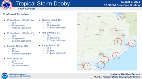
Some of the areas inspected for erosion are locations where tornadoes spawned by the storm touched down. The National Weather Services lists seven confirmed tornadoes from Debby, several of which did significant damage to some businesses and residences. Edisto Beach got hit with two.
Almost 8,000 people were without power as of Thursday afternoon, according to Andrew Bateman, acting director of the South Carolina Office of Regulatory Staff. Spartanburg and York counties had the most storm related outages as of 1 p.m., he said.
Additional rain is likely to bring total rainfall to 20-25 inches in the eastern part of the state, according to the National Hurricane Center’s Thursday afternoon update. Most of the state is now at a slight risk of flash flooding, with at least a 15% chance.
As of Thursday morning, Summerville had received the most rain with over 18 inches since Saturday. Mount Pleasant, Edisto Beach and Beaufort all had over 15 inches.
