I was wandering the lovely back streets of Greenwich last week, past the theater and the fan museum (both marvellous, and I found myself in Royal Hill. I looked to see if the building that used to be home to The Cheese Shop, a business that used to be run by a lovely guy I met on a plane coming back from Zakynthos in the late 1980s, was still there. The terrace of shops hasn't changed much, I think his shop was one of these next to the butcher. I continued up the street, admiring all the lovely houses, and stopped to look at the fab tiles on the Barley Mow pub at the corner of Point Hill, now a restaurant.
 Barley Mow pub, Royal Hill greengrocer, Royal Circus tea merchant
Realising that I was supposed to be meeting a friend in the Oxford Street in thirty minutes, I started making my way down the hill via Prior Street towards the station. I looked to the right and noticed that there appeared to be quite a wide angular gap between the houses here behind this tree, and I looked back and forth at that and at the twentieth century flats behind me, considering that there must have been a railway line here.
A couple walking their small friendly dog saw my quizzical face and asked if I was lost. I explained my thought process to them. Well, what a delightful interlude it turned out to be. John said yes, that he had wondered that too, but he hadn't been able to find out any info. The conversation progressed and I said I'd look into the things we discussed. I cave him my card and asked him to keep in touch. But I have decided to write it up here. Just shows how one bit of 'perhapsing' can evolve into a half a day of sleuthing! I do hope John is reading this. And I hope I have remembered his name correctly as I tend to forget what you'd call 'normal' names. His wife, who has lovely eyes, is called Della. Nice people.
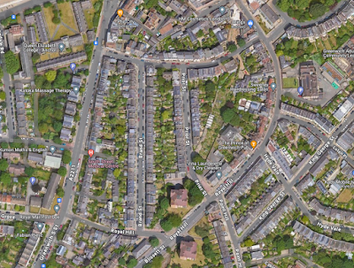
Here's the Google view of the area today – I was standing were the word Vina [Launderette] is:

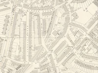
As you can see, there are allotments here which are often a hint at old railway lines or sidings, indeed that's what John thought, that this was sidings. I thought it was more likely to be a connecting line from/to Lewisham, which was confirmed when I found this 1890's OS map available on Layers of London – many of the road names have changed and this isn't exactly the same proportion and crop as the pic above, but it's easy to make the comparison:

I had assumed the railway line then fed into into the eastbound service towards Maze Hill but, no, it ended at 'Greenwich Terminus' on Stockwell Street, site of the Ibis Hotel today.
John also mentioned that he was intrigued by an old sign near the old Old Barley Mow pub which he wondered might have been a coal merchant. Ooh I thought... lets go and have a look! By this time I realised I was going to be even later for my appointment in central London but, luckily, I was meeting a friend who is as fascinated by these things as I am, so he'd understand!
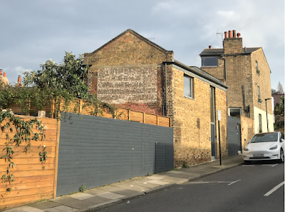
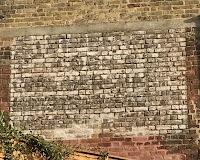
I turned to look back past the pub where there is a hand-painted ghostsign on a building that looks to be No.1 Point Hill, but is actually constructed in the back garden of No.1 King George Street. I took a few photos:

There are multiple layers on this sign. Looking my the phone screen we found it was easy to make out CORN & COAL MERCHANT through the middle but the names were hard to decipher. For instance, there's a name in a curve at the top and other in a straight line. The last word at bottom right could be RAIL, perhaps making use of the adjacent railway line.

For more of my ghostsigns observations, simply use the search box or click here.
