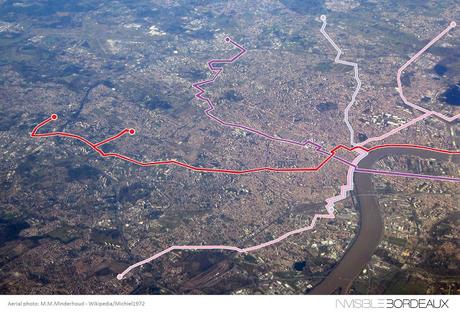
This concise post was inspired by a Twitter publication showing an aerial view of London that also displayed the actual path of the Underground network. I trust that you will agree... a Bordeaux version of the picture needed to be designed!
The original aerial photo of Bordeaux was taken in January 2012, is credited to M.M. Minderhoud, and has been reused and adapted here under the Creative Commons license. The four tram lines have been cunningly overlaid on the picture through the not-very-expert use of elementary picture editing tools! Of course, one great regret is that a substantial part of the Metropole is not visible; therefore tram line A cuts off here before it reaches Cenon and Lormont, line B doesn’t quite reach Pont d’Aquitaine, and one branch of line C stops short of Bordeaux-Lac!
However, the picture does show just about the whole of Bordeaux proper, and pans out very nicely to the north, west, and south of the city. If you know of a more representative picture that could be used, get in touch and I’ll happily start again! In the meantime, I hope you like this first version!
> Download the high-resolution version of the picture here.
Note: The original London picture which inspired this post (available here) was notably shared by the historian, geographer and TV presenter Tim Dunn, and by Suede bassist Mat Osman. The photo was credited to DJ Santero while the Underground map was plotted by the urban developer and designer Martin Bangratz.
