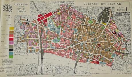
It’s a pre-war (1936) map of the City of London that colour-codes it. Sort of like showing the organs of the human body, their position relative to one another and what they each do.
What the map makes clear is that the “flocking instincts” of “birds-of-a-feather” was the shaping principle. (Dropped my jaw open, that. Who’d a thought it? That – along with all those warehouses [see below] – is what jumps out at you. And gives pause for thought.)
It’s a City of London that’s both near and far. It’s a City of London that’s right on the edge of living memory. A City of London pre-Big Bang, pre-lots of bangs (World War II bangs), pre-all-the-other-bangs that 77 years bring.
At “internet/blog” resolution it won’t be easy to read the explanatory “colour-coding” notes, so I’ll spell those out here.
The yellow bits are “Residential”. There aren’t very many of them – the point being that even as long ago as the 1930s there weren’t many people living in the City of London.
The brown areas are “Commercial”. Offices in other words. Interesting how it ‘s concentrated in the eastern half of the City. Also interesting: the comparison with today’s City. “Commercial” has made the running in the last half century or so. It’s what’s carried all before it in the City of London of our era.
The rose coloured stuff is Warehouses and Wharves. More or less solid wharves along the river’s edge. All gone now. And a surprisingly large swath of warehouses runningright up the central axis. Also more or less all gone now. A few of the physical structures have survived but they’ve all been converted to offices. They’re “warehousing” digital impulses these days.
The red stuff is wholesale markets. Happily, Smithfield is still there. Same goes – including the sentiment – forLeadenhall. Though it’s been completely gentrified.
The pinkish stuff – most of it toward the western and northern edges of the City – is Industrial. A lot of the western edge “Industrial” will have been the production plants for London’s huge newspaper industry. Ubi sunt now of course.
The gray is – in the map’s parlance – “Statutory Undertakings”. Bridges, railway stations, etc.
The black is “Shops and Stores (Retail)”.I’d say there’s probably a bit more of that now.
The blue is “Public Buildings”. St. Paul’s Cathedral, churches, Bart’s Hospital, the General Post Office, the Old Bailey, etc.
The green is “Open Spaces and sites of Disused Burial Grounds.”
And on that note – well, I’ll leave you to it.
A London Walk costs £9 – £7 concession. To join a London Walk, simply meet your guide at the designated tube station at the appointed time. Details of all London Walks can be found at www.walks.com.


