 Now the present
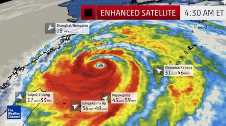
super typhoon - after battering Okinawa Thursday into early Friday Japanese
time, Typhoon Chan-hom is headed for landfall in eastern China. According to wunderground.com, Chan-hom has the potential to be the
strongest typhoon to make landfall within 200 miles of Shanghai in at least 35
years. There is also the Super Typhoon
Nangka in the western Pacific Ocean. It intensified to super typhoon intensity
well north of Saipan Thursday night, local time. Nangka's maximum sustained
winds are estimated to be 150 mph at this time, making Nangka the equivalent of
a high-end Category 4 storm on the Saffir-Simpson Hurricane Wind Scale.
So, China is bracing for the arrival of a strong storm this weekend after an earlier one fizzled out over land.Typhoon Chan-hom was churning near Japan's Ryuku Islands early Friday, with maximum sustained winds of around 213 kph (132 mph).Chan-hom's strong winds and torrential rain were also forecast to affect northern Taiwan, where some school and office closures were expected Friday afternoon, according to local media.Approximately 1,020 flights to and from the airport had to be rescheduled because of the weather system, an airport authority spokesman told CNN. More to follow as the typhoon makes a landfall ! PS : there was another typhoon by the same name - Typhoon Chan-hom, known in the Philippines as Typhoon Emong, was the sixth tropical depression and the second tropical stormto develop during the 2009 Pacific typhoon season. On May 6, the storm intensified into a Category 1 typhoon, and on May 7, Chan-hom intensified into a Category 2 typhoon equivalent. However, Chan-hom weakened into a severe tropical storm after passing northernLuzon. It was to dissipate later- Laos had submitted the name, which means a kind of tree. With regards – S. Sampathkumar
10th July 2015.

