 Streets Ahead is the column
from London Walks' Pen David
Tucker…
Continued from yesterday (catch up with that post HERE)
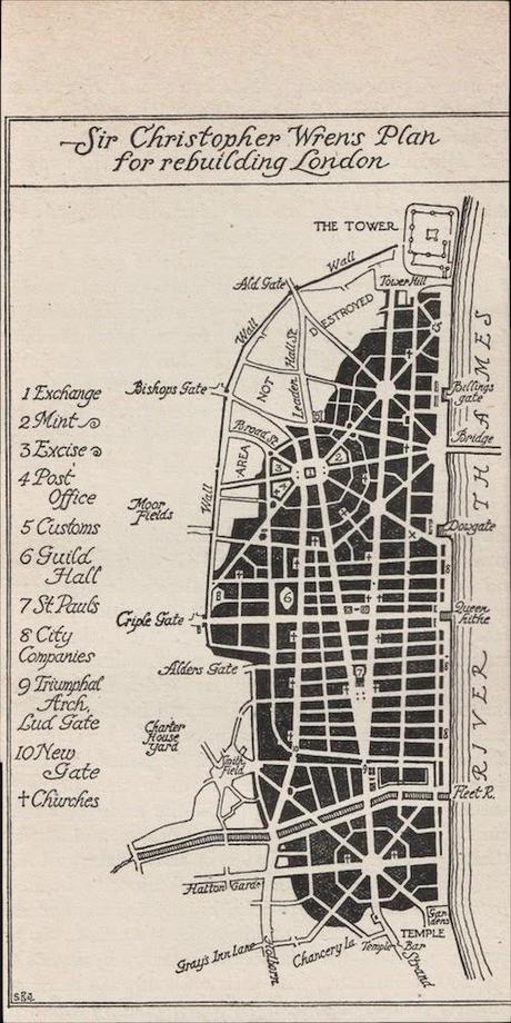 Anything else? Yes. The logic of street
sizes. The main thoroughfares, running east to west, would have been 90 feet
wide. The secondary streets would have been 60 feet wide. The little streets 30
feet wide.
As for the river frontage… For it Wren envisaged a wide, indeed a noble quay. An esplanade divided up ever so sensibly. The eastern, downstream end of it – from Dowgate to the Tower – would have been for commerce. The western end was to be a terrace punctuated with the halls of the City Companies. There they were to be, a parade of them rejoicing in their wealth and might and the grandeur of their riverside setting.
Yeah, not bad at all. And it was completely stillborn. None of it happened. The City’s commercial and other vested interests won out. Wren couldn’t get over the barbed wire emplacements of the City’s deeply ingrained instincts for private property, couldn’t overcome the complex mosaic of centuries-old land ownership.
What could have been. Pretty to think about, isn’t it?
And as for what we got instead. Well, in terms of streets and street “pattern” (f you can call it a “pattern”) and building line, well, it was pretty much business as usual. The old layout. The time-honoured fissures, the old lines. Just two new streets – King William Street and New Queen Street. Everything else just as it was – or just where it was – before the fire.
This 18th century map tells all. It was the reality. And it’s much closer to our London than the London that Wren envisioned.
It repays close examination.
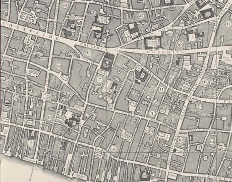
It’s a tangle. A rat’s nest of streets. Everything’s higgledy piggledy. Maybe start your scrutiny by looking at the Royal Exchange and its environs (see the big street CORNHILL – the Royal Exchange is directly above it) and comparing it with what Wren envisioned.
And maybe for seconds take a look at the warren of courts and alleyways between College Hill and Dowgate Hill (just to the east of the Number 22 on the map). The street names – this is more or less always the case in London – are a joy: Naked Boy Court, for example. And Elbow Lane. And Sugarloaf Court.
I’ll take it. Avenues north and south and streets east and west as they do these things in New York has its advantages – you can get off the boat from Uzbekistan, a brand new American, and be at the wheel of a yellow vehicle – be a New York cabbie – inside of a week. As opposed to the five or so years of “doing the knowledge” that it’ll take you to become a London cab driver. So, yes, there are certain advantages, but I’ll take London. Take it every time. Take every neighbourhood being its own snowflake of complexity and individuality. Take it in its full-on higgledy piggledyness.
Not least because, hey, we probably wouldn’t have a job if Wren had got his way. Who needs a guide if it’s dead easy to find your way around?
*Or, for that matter, any of half dozen or so London Walks that we do in the City.
A London Walk costs £9 – £7 concession. To join a London Walk, simply meet your guide at the designated tube station at the appointed time. Details of all London Walks can be found at www.walks.com.


