 Streets Ahead is the column
from London Walks' Pen David
Tucker…
Going on the Bloody, Flaming, Poxy London walk on Monday? Want to “read in” a bit?
These two maps will “prep” you very nicely.
Starting with this one.

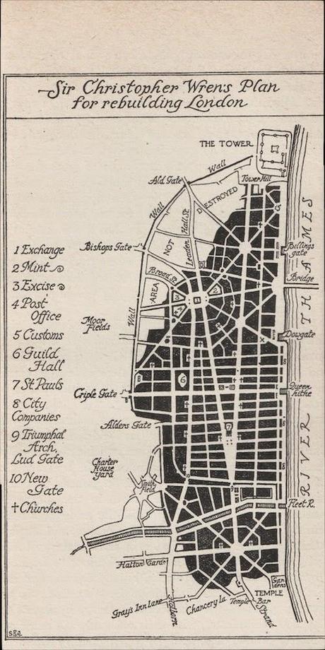
It is, as you can see, the London that we’d have if Christopher Wren had got his way. It’s his plan for the rebuilding of London after the Great Fire pretty much wiped the slate clean.
In fact, one of the fascinating things about the map is that it shows us exactly how much of London was put to the torch – completely burned out – by the Great Fire. And how much of it escaped the conflagration. You can see the legend – “AREA NOT DESTROYED” – in the upper left hand corner. It’s the white bit, the bit of edging crust. The rest of the map is the same ash black that virtually the whole London pie – 373 acres – had been reduced to.
Wren’s plan is a masterpiece of lucidity, urban beauty and common sense.
The Wren-planned London would have had two main focal points and three subsidiary ones.
The eastern focal point would have been the Royal Exchange. As you can see it would have had 10 streets radiating out from it. And as cogwheels to that urban sunburst, two subsidiary, neighbouring foci, with eight and six streets radiating out from them. The three of them would have given London interlocking fields of fire, as it were, converging on the supremely important target: London Bridge.
The other focal point was of course St. Paul’s. Approached from the west, as the explanatory notes make clear, through a Triumphal Arch at Ludgate and then along a gradually opening up public space vista.
Coming from the other direction, the east, the cathedral crowns the apex of those two converging great avenues.
Then there’s the western antechamber of London: Extra-mural* London. In other words, Fleet Street and its environs. The tangle of alleys and courts off Fleet Street has been turned into something grand, something that unfolds with the perfection of a rose. Eight streets radiating out from about where St. Dunstan’s in the West stands today. Riverine vistas at the end of four of the streets – three to the Fleet River, one to the Thames. A garden vista (and the Thames beyond it) at the end of a fifth street. The mighty Strand – Go West, young man, go west – and Royal London vista-ing the sixth street radiant. And for the remaining two, vistas of the green hills to the north and northwest of London.
Not bad, eh? *So called because it’s outside the wall
Part Two will be posted tomorrow. A London Walk costs £9 – £7 concession. To join a London Walk, simply meet your guide at the designated tube station at the appointed time. Details of all London Walks can be found at www.walks.com.


