GR: This year’s fire season isn’t over. Southern California will have hot wind and high temperatures for the next few days. The article below from the Weather Underground has information about current conditions and past comparisons. This event calls attention to the deepening environmental crises global warming is causing. While we should be focusing in disaster planning, Congress is wrangling over how much more of the forest timber companies can cut in the name of wildfire management. If you are unfamiliar with this issue, I highly recommend the article by George Wuerthner that is introduced here.

“According to NOAA, the hottest temperatures ever recorded after October 23 in Southern California (along with the Weather Underground forecast for Tuesday) were:
- 105°F Riverside, 10/28/1915 (WU forecast for Tuesday: 100°F)
- 101°F LAX Airport, 11/1/1966 (WU forecast for Tuesday: 96°F)
- 101°F Longbeach, 11/1/1966 (WU forecast for Tuesday: 100°F)
- 100°F Downtown Los Angeles, 11/1/1966 (WU forecast for Tuesday: 101°F)
- 100°F Burbank/Glendale/Pasadena, 10/26/2003 (WU forecast for Tuesday: 99°F)
- 100°F San Diego, 11/4/2010 (WU forecast for Tuesday: 91°F)
- 99°F Bakersfield, 10/27/1906 (WU forecast for Tuesday: 90°F)
“The heat wave and Santa Ana winds will be caused by a large near-record-strength dome of high pressure expected to settle in over the Great Basin, a few hundred miles northeast of Los Angeles. The difference in pressure between this high-pressure system and lower pressure over Southern California will drive gusty northeast winds over Southern California. Since these winds will originate over desert areas, they will be hot and dry. As the air descends from the mountains to the coast, the air will get hotter and drier, due to adiabatic compression—the process whereby the pressure on a parcel of air increases as it descends, decreasing its volume, and thus increasing its temperature as work is done on it.

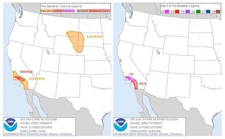
Figure 1. Fire weather outlooks for Saturday, October 21, issued by the NOAA/NWS Storm Prediction Center at midday Friday (left), and into next week (Days 3-8) issued late Thursday (right). The Day 3-8 outlooks do not indicate risk level, but forecasters noted: “A prolonged period of at least moderate offshore winds and critical fire weather conditions will be likely across much of southern CA from Day 3/Saturday through Day 6/Tuesday.” Image credit: NOAA/NWS/SPC.
A four-day period of critical fire danger
“As of 11 am EDT Friday, fire weather conditions are predicted by the NOAA/NWS Storm Prediction Center to be in the “elevated” to “critical” range Saturday through Tuesday across the coastal mountain ranges and foothills north of the Los Angeles Basin (fire weather alert levels come in three levels of severity: “elevated”, “critical”, and “extreme”.) Wind gusts of 35 – 50 mph will be capable of causing rapid spread of any fires that might ignite, though these winds will not be as strong as the ones that created the deadly firestorm in California’s wine country earlier this month. The fire danger increases through Tuesday, as the heat builds, and relative humidities below 10% are expected in many areas. Conditions at night will not help firefighting efforts much, as temperatures will only cool down to the mid-70s, with low humidity and strong winds. By Wednesday, the heat and fire danger will begin to diminish as the Santa Ana winds die down and cooler, more humid air moves in, but temperatures will still be in the mid-90s in the Los Angeles area. Such a long period of extreme heat and Santa Ana winds mean that any fires that do ignite will be difficult to control and will potentially burn a large area.” –Jeff Masters (New Fire Danger Threatens to Worsen Most Disastrous Wildfire Season in California History by Dr. Jeff Masters | Category 6 | Weather Underground).

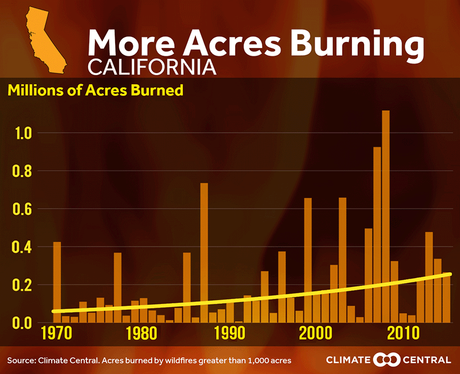
Figure 3. The number of acres burned in California has been increasing since 1970, due to a warmer and drier climate, in combination with fire suppression policies that have left more fuel to burn. As we wrote in our October 13 post, human-driven climate change and development patterns are making destructive firestorms more likely. The average length of the wildfire season in the western U.S. is more than 3 months longer than in 1970, largely due to climate change, according to Climate Central.

