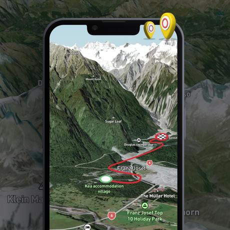
For outdoor enthusiasts seeking the best tools to enhance their hiking adventures, apps like Outdooractive have been popular choices. However, there’s a rising star in the hiking community that’s offering even more: HiiKER. With its focus on high-quality topographical maps and advanced features, HiiKER is positioning itself as the premier alternative for those who want to navigate trails with confidence and precision.
Why HiiKER Stands Out as an Outdooractive Alternative
Access to Premium Topographical Maps
While many apps rely on standard mapping sources, HiiKER provides access to premium topographical maps from some of the most reputable mapping agencies worldwide:
- Ordnance Survey UK
- USGS (United States Geological Survey)
- Ordnance Survey Ireland
- Harvey Maps
- Kompass Maps (Europe)
- VicMap (Australia)
- EastWest Maps
- And many others
Benefits of Premium Topo Maps
- Exceptional Detail: Get accurate contour lines, elevation data, and terrain features essential for serious hiking and trekking.
- Reliable Updates: Premium maps are maintained by official agencies, ensuring up-to-date information.
- Enhanced Safety: Detailed maps help you avoid hazards and navigate challenging terrains with greater confidence.
- Discover Hidden Gems: Access trails and natural features not commonly found on standard maps.
Advanced Trail Planning and Recording Tools
Creating routes on HiiKER’s premium topo maps (Harvey Maps)HiiKER’s robust planning tools allow you to:
- Create Custom Routes: Design your own trails with precise control over your path.
- Set Waypoints: Mark campsites, water sources, and points of interest.
- Analyze Terrain: Assess elevation profiles and terrain types before setting out.
- Record Your Journey: Use GPS tracking to record your hike, monitor your progress, and share your adventure with others.
Multi-Platform Accessibility

HiiKER is available on Android, iOS, and web platforms, ensuring that you can plan and access your hikes across all your devices. Start planning on your desktop at home and seamlessly transition to your mobile device on the trail.
Offline Access to Maps and Trails
Never worry about losing your way due to lack of signal. With HiiKER, you can download premium maps and trail information for offline use, which is crucial for:
- Remote Adventures: Stay on track even in areas without internet connectivity.
- Battery Conservation: Reduce the need for constant data fetching.
- Data Savings: Avoid using mobile data while navigating.
Extensive Library of Curated Trails
Discover thousands of trails curated by the HiiKER team and community members. Each trail comes with detailed information, including:
- Difficulty Level
- Distance and Elevation Gain
- User Reviews and Ratings
- Trail Conditions and Points of Interest
Why Switch from Outdooractive to HiiKER?
- Superior Map Quality: Experience the difference with detailed and reliable premium topo maps.
- Enhanced Planning Tools: More control and options when planning your adventures.
- Community Engagement: Join a growing community of hikers sharing insights and experiences.
- User-Friendly Interface: Intuitive design makes navigation and planning straightforward.
- Dedicated Support: Responsive customer service to assist with any queries or issues.
Getting Started with HiiKER
Making the switch is easy:
- Download the App: Available on the Google Play Store and Apple App Store.
- Create an Account: Sign up for free and start exploring.
- Explore Premium Maps: Upgrade to access the full range of premium topo maps.
- Plan Your Next Adventure: Use HiiKER’s tools to map out your next hike.
Conclusion
While Outdooractive offers a range of features for outdoor enthusiasts, HiiKER takes your hiking experience to the next level with its focus on premium mapping and advanced planning tools. Whether you’re a casual hiker or a seasoned adventurer, HiiKER provides the resources you need to explore the outdoors safely and confidently.
Embark on your next journey with the best maps at your fingertips. Download HiiKER today and redefine your hiking experience.
