


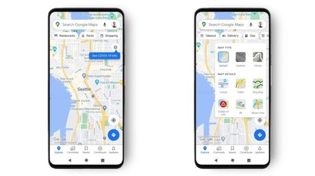
Google has ad a new COVID-19 information layer for Google Maps to help Android users avoid the coronavirus pandemic. The new feature displays case data on trends in more than 220 countries around the world, where Maps is available.
You can see a 7-day average of new COVID-19 cases per 100,000 people in an area. The COVID-19 layer will be able to show you the data for as long as the state, district or city has made it public.
The new feature will help people decide whether or not to visit a particular region, where there might be a possibility of infection.
This is all in addition to the existing functionality of Maps, where Google already offers COVID-19 alerts to notify users of delays at metro stations, travel restrictions, and more.
Much like the traffic state, Google has added a color code to the new COVID layer that will help users quickly distinguish areas with high case density. For example, an area highlighted in dark red will have more than 40 cases. Here are the color options used in Google Maps' new COVID-19 layer:
How to activate the COVID-19 layer of Google Maps?
Now, activating the coronavirus information layer is a simple task. The option is available alongside other Google Maps layers like Traffic, 3D, Street View, and the new street light layer.
Open Google Maps on your Android or iOS device, then tap the "Layers" button in the top right corner. Now tap on the " COVID-19 Info " option under Card Details, and you are good to go.
One thing to note is that you might not see the feature right away; it will be rolled out to all users around the world during the week. So, it may take some time before the COVID layer option arrives on your device.
Google collects data for the COVID layer from a variety of trusted sources including John Hopkins, Wikipedia, and The New York Times. The company also sources from WHO and local authorities such as Brihanmumbai Municipal Corporation (BMC) in India.
The COVID-19 Layer: Google Maps Gets Most Useful Feature of 2020 appeared first on Fossbytes.