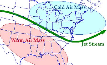
Here in the northern mid-latitudes (much of Canada and the US, Europe, and the northern half of Asia) our weather is governed by the jet stream. This high-altitude wind current, flowing rapidly from west to east, separates cold Arctic air (to the north) from warmer temperate air (to the south). So on a given day, if you’re north of the jet stream, the weather will probably be cold; if you’re to the south, it will probably be warm; and if the jet stream is passing over you, you’re likely to get rain or snow.

The jet stream isn’t straight, though; it’s rather wavy in the north-south direction, with peaks and troughs. So it’s entirely possible for Calgary to experience a cold spell (sitting in a trough of the jet stream) while Winnipeg, almost directly to the east, has a heat wave (sitting in a peak). The farther north and south these peaks and troughs extend, the more extreme these temperature anomalies tend to be.
Sometimes a large peak or trough will hang around for weeks on end, held in place by certain air pressure patterns. This phenomenon is known as “blocking”, and is often associated with extreme weather. For example, the 2010 heat wave in Russia coincided with a large, stationary, long-lived peak in the polar jet stream. Wildfires, heat stroke, and crop failure ensued. Not a pretty picture.
As climate change adds more energy to the atmosphere, it would be naive to expect all the wind currents to stay exactly the same. Predicting the changes is a complicated business, but a recent study by Jennifer Francis and Stephen Vavrus made headway on the polar jet stream. Using North American and North Atlantic atmospheric reanalyses (models forced with observations rather than a spin-up) from 1979-2010, they found that Arctic amplification – the faster rate at which the Arctic warms, compared to the rest of the world – makes the jet stream slower and wavier. As a result, blocking events become more likely.
Arctic amplification occurs because of the ice-albedo effect: there is more snow and ice available in the Arctic to melt and decrease the albedo of the region. (Faster-than-average warming is not seen in much of Antarctica, because a great deal of thermal inertia is provided to the continent in the form of strong circumpolar wind and ocean currents.) This amplification is particularly strong in autumn and winter.
Now, remembering that atmospheric pressure is directly related to temperature, and pressure decreases with height, warming a region will increase the height at which pressure falls to 500 hPa. (That is, it will raise the 500 hPa “ceiling”.) Below that, the 1000 hPa ceiling doesn’t rise very much, because surface pressure doesn’t usually go much above 1000 hPa anyway. So in total, the vertical portion of the atmosphere that falls between 1000 and 500 hPa becomes thicker as a result of warming.
Since the Arctic is warming faster than the midlatitudes to the south, the temperature difference between these two regions is smaller. Therefore, the difference in 1000-500 hPa thickness is also smaller. Running through a lot of complicated physics equations, this has two main effects:
- Winds in the east-west direction (including the jet stream) travel more slowly.
- Peaks of the jet stream are pulled farther north, making the current wavier.
Also, both of these effects reinforce each other: slow jet streams tend to be wavier, and wavy jet streams tend to travel more slowly. The correlation between relative 1000-500 hPa thickness and these two effects is not statistically significant in spring, but it is in the other three seasons. Also, melting sea ice and declining snow cover on land are well correlated to relative 1000-500 hPa thickness, which makes sense because these changes are the drivers of Arctic amplification.
Consequently, there is now data to back up the hypothesis that climate change is causing more extreme fall and winter weather in the mid-latitudes, and in both directions: unusual cold as well as unusual heat. Saying that global warming can cause regional cold spells is not a nefarious move by climate scientists in an attempt to make every possible outcome support their theory, as some paranoid pundits have claimed. Rather, it is another step in our understanding of a complex, non-linear system with high regional variability.
Many recent events, such as record snowfalls in the US during the winters of 2009-10 and 2010-11, are consistent with this mechanism – it’s easy to see that they were caused by blocking in the jet stream when Arctic amplification was particularly high. They may or may not have happened anyway, if climate change wasn’t in the picture. However, if this hypothesis endures, we can expect more extreme weather from all sides – hotter, colder, wetter, drier – as climate change continues. Don’t throw away your snow shovels just yet.
