It’s rare that I would ever recommend anything produced by the BBC (in fact, I don’t watch a lot of telly at all) but when a Facebook page alerted me to the arrival of a series on walking perhaps Britain’s most challenging long-distance trail, The Pennine Way; I just had to tune in!
Click Here for Episode One
…On iPlayer, of course. In case you haven’t already seen it yourself (it was first broadcast back in April), you can also watch it on the iPlayer for free (just search “Pennine Way“) – although, it will only be available for another twenty-seven days, at the time of writing.
This four-part series of thirty-minute episodes showcases some of the highlights along the 267 mile route. It isn’t one-man walking the entire distance. Along the way, presenter Paul Rose heads underground, on to the water and even up an asserting rock face.
Along with several other locations around the country, I’ve been wanting to visit the Yorkshire Dales and to explore the landscapes somewhere further north of the Cotswolds. I’m not currently in a position to be able to walk the whole thing in one go but I like the idea of doing a small section, perhaps once a year.

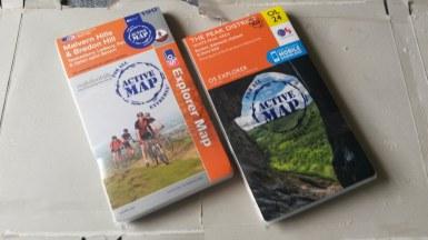
This trail begins in the Peak District and, as you can see above, I have just purchased a couple of brand-new OS maps for the new month (one of which is also my first purchase of the new maps including a downloadable version for a smart phone). My map covers the White Peak, to the south and, on the back I got a bit excited when I spotted the Pennine Bridleway labelled as one of the routes… But this is something entirely different to the route as featured in the BBC’s film. The Pennine Way starts in Edale, which is a short jump north of the map I now own and is only covered by the Dark Peak District map…
And it was almost so very convenient, as I hope to be able to spend a weekend there later this month!
Buying new maps each month has become a bit of a personal habit over the summer this year. My grand total currently stands at seventeen and there’s an undeniable chance of surpassing twenty by this time next year. In time, I’m going to need a convenient and efficient means of storing the lot.

I also bought myself an OS map covering the Malvern Hills near Worcestershire. It’s a relatively small area of hills, compared to some of its closest neighbours. As it’s only a ninety-minute drive there as well, I don’t see much point in driving when I could spend a day up there are cover many of the peaks in one go; perhaps returning on a second occasion to pick up on the ones I miss.
Thanks for reading and do take a look at those videos.
