Langs Lookout, Mount Alexander
If you asked me four years ago where Mount Alexander was, I'd have directed you to the road with the same name which runs through Moonee Ponds. Don't forget though, I came from a background where all I believed a bloke needed in life was a fast car and hot chicken.
Anyway, once I realised it was an actual mountain, I'd been meaning to get up there and take a look. Even then it's taken me a couple of years to organize a day hike to the place, but once I did, I liked it so much I've been there twice. Once on a steaming hot summers day and the other last week on a balmy autumn day. In fact, the weather has been so mild in Melbourne I don't think there was much of a temperature difference between the two trips!
There were also a couple of things I missed on my first trip which left me keen for a second look. How about not even being on the actual summit? Huh? I assume when you climb a mountain and get to the top where lookouts and massive television towers are, that'd be the top? Umm... No, it's not. There was also an old granite cottage tucked away in the bush, which I'd missed on my first trip, so that was something which needed to be inspected.
So, what you'll find in this post is a combo of photos from both trips. The Parks Victoria map has the walks starting halfway up the mountain, but I followed the notes from 'Victoria's Goldfield Walks' which begins lower down at McQuillans Road.
This has been one hell of an overblown intro, but it's over and the walking has commenced. There's one noticeable thing about this area. It's dry as a chip and on both trips, there's not a lot which is green. Talk about a lack of rain. On that note, I noticed the long term forecast for the next three months is warmer than average. This isn't good for a bloke whose maximum output efficiency is achieved in temperatures below 15 °C. Anything over and you'll find me flaked out on the couch.

The start of the walk...
On the stroll up between the fences I did notice something of interest. A discarded skin lay among the grass which I assume was from a snake?

Following the skin sighting I was now watching every step through the grass, as the track headed uphill. As I've always said before, there aren't many walks where there's a casual intro. This was the same and the initial climb had me cursing I wasn't carrying a defibrillator with me. Then suddenly a structure appeared, which had been delivered by the hiking gods. A chair.

I collapsed onto the seat and noted two things. My heart was racing so fast I couldn't keep count of the beats and the view is fantastic. In fact, the vista is so good, it took my mind off an impending stroke.

Chair view.
There's a lot of walking to come, so I couldn't stay seated for too long. The track winds it's way up, passing some nice, curved bark trees...

...before reaching a spot called 'Dog Rocks'. As you can probably guess, there's lots of rocks here. Not just any rocks though, but massive ones...

It's a great spot and judging by the remains of the odd fireplace, other people think so as well. Camping amongst these huge rocks would be quite an enjoyable night out, but there's no water here. Actually, is there any water any where lately?
The odd tree has had to grow around these boulders...

One can't stop though, as the fearsomely named 'West Ridge Walking Track' has to be tackled. I'm not really sure what happened next, as it's only 2.7 km from Dog Rocks to the top of Mount Alexander, but it took me decades to walk that piddly distance. It's uphill, but I think the undulating terrain weaving up amongst rocks was the cause of my sloth-like speed. It has plenty of sights though and incongruously, tree ferns appear in this parched landscape.

The hillside is also steep at times...

...but, it's not always nature along here. I spotted a 'ye olde' steel tin lying amongst the grass. Was it a relic from the days of the goldrush in the surrounding area? I couldn't really tell though, as upon closer inspection it was full of bullet holes...

Oh well, you can't have it all. There were plenty of fallen trees around which always look nice under filtered sunlight.

On my summer trip I stumbled across an echidna at the side of the track, but unfortunately didn't spot him until the last minute, so my biblically loud foot-stomps had him burying himself as I arrived. His face was well hidden for protection.

Armour deployed.
The track continued up, passing the boulders of 'Scorpion Rocks'...


...before the landscape opened out near the top. There's one thing about this park though, which shows Parks Victoria don't have two cents to rub together. This obliterated sign was untouched on both trips and I'm pretty sure it'll remain this way for the next 200 years. Yes, 200.

I could hear the buzzing sound of a generator, so I knew the top was close. Unfortunately this is another mountain covered in enormous masts. I've no idea what they service, but no doubt it's for something important?
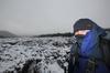
Anyway, stumbling onto flat ground at last, I located 'Langs Lookout' via guess work...

... and descended to the large flat rocks for a much needed rest. It's not a bad spot for a breather either.

On both occasions, I spent well over half an hour lying on warm rocks, with the wonderful thought it's all downhill from here.
Well, maybe. After leaving the lookout, my walking notes throw in a tricky doosra. The descent veers off the Joseph Young Drive which leads to the top of the mountain and instead plummets down the 'Goldfields Track' for a while. This is nice, but the catch is after steeply descending, it rises back up an old 4WD track to the road again. On my summer jaunt, I followed this method and found myself almost vomiting from the sudden drop in height, which is then regained in about ten feet. I didn't really find much to look at either. Unless you're into shotgun shells...

This also created a reason for the second visit. I hadn't been to the top of Mount Alexander at all. I assumed by getting to Langs Lookout I'd summited, but the highest point is actually next to the road a short distance away. I'm not going though horror without bagging the summit, so the autumn tilt had me avoiding the 'Goldfields Track' and instead following the road down.
It's far nicer walking for the lungs as well, and as road bashes go, it's not bad. On both occasions I barely saw a car, so it's quite comfortable, but best of all, it's downhill! Actually, the summit was insanely easy to reach, as it's right next to the road. The sign indicates the lofty heights I was standing at...

...and a short distance away is the summit cairn, which is a peculiar beast. Part chimney looking and part something, the peak was successfully bagged.

Mt Alexander summit cairn.
With one of the attractions I missed out on in the first trip completed, I continued down the road. There's plenty of curves for photo opportunities...

...the odd feather...

...and friendly wallabies who wave as you pass by.

"Hi!"
Next up was the old granite cottage. On the summer visit I was intending to track it down, but found myself thoroughly wrecked from the heat, so abandoned the idea. The ruins sit off the road and tracks, so a bit of work is required to find it. For some reason it's not even mentioned on the Parks Victoria blurb for the area...?
Anyway, after descending I headed off the road at a point where I thought it was nearby. It was actually quite easy to find, as it appeared through the trees...

'Daywalks Around Melbourne' by Glenn 'Guru of Good Times' Tempest, has this particular walk described as well. The book is over eight years old though, so a trip down to the cottage is not included in his GPS route for the walk. I guess it's because the ruins sit near an old track which although marked on the Parks Victoria map, appears to have vanished? What confused me more was earlier in the day I walked on the west side of the mountain on West Ridge Walking Track. Now on the east side there's the track which has now vanished and it's also called the West Ridge Walking Track. Mm... Tricky.
Anyway, I looked online and couldn't find anything about this building other than what's in GT's book which he describes as,
"...remains of a silk factory belonging to a Bladen Neill. It was started in 1873 with the intention of employing local women, but the enterprise closed in 1877..."
So, that's as much as what I know about the place. All I can say is it's kind of tiny for a 'factory'. It was late in the day on my autumn trip, so the low sun was creating a nice golden glow through the old window...

I'm not sure what made it collapse over the years, but I assume it was cannibalized at some point?

A number of old red bricks also lie around the area. Do you realize in my running days I'd go for runs with half a brick in each hand? That sure was a crowd pleaser in the places I used to go running, as I took the 'running wanker' to extremes. Anyway, holding this brick up took me back to those supremely fit days...

With one last shot taken from the other side of the window, I left leaving the ruins behind...

...and made my way back to the road and track which joins up with the trail I'd followed earlier in the day. Light was really fading now, as I reached the chair from the hiking gods. A blazing red sky...

...had me wanting to wait until the sun vanished though...

...just so I could get some photos of the afterglow in the sky...

...and the clouds around.

The only trouble was it was almost dark and I was still half-way up the mountain. Luckily with about half an hour of light left I zipped down the hillside. If you look at the GPS route later though, you'll notice I took a wrong turn on both occasions I descended. The track is not clear in places, but the direction is, so getting down isn't a problem.
In autumn I reached the car in almost complete darkness. How about summer though? Oh yeah, it was a complete difference. The sun was still blazing as I passed this old tree...

...and guitar. Guitar? Yes, of course, a guitar...


I find some crap on walks, but I can't say I've seen any musical instruments before.
In autumn I drove away with the headlights on, but in summer I motored on with the smell of smoke in the air. Smelling smoke in summer whilst out bush is a hikers nightmare, but even in the car it was disconcerting, especially as it seemed to be getting stronger.
I dropped my speed and as I climbed a hill the sky was full of smoke. A grass fire was speeding across the paddocks next to me...

...and sirens of the fire brigade were ringing from all directions. I found out later this fire was accidently started by a local using some machinery. The flames were heading away from me, but it was amazing how fast they were moving...

It reached the nearby Calder Highway, but I don't think it jumped the road.
Since the Black Saturday bushfires, I try to avoid hiking on a hot, windy day, as this little grass fire reinforced. Flames being fanned move insanely quick, so I don't want to be anywhere near them. Not unless you want a new blog, 'Burnt Ass Fiasco' to start up?
That's it then. In GPS terms, you get a 'two for one' offer. Here's the first trip...
...and here's the second...
You can see in the second trip the variation where I trundled down to the cottage ruins. It also shows why this walk is a little painful in spots. 663 metres in climbing for the day is enough to get the heart rate up a little, but it's a great walk. It's so good, I've done it twice!
If you ask me now where Mount Alexander is, no longer will I direct you to Moonee Ponds, but instead to just outside Castlemaine. I suppose I should leave with another sunset photo...?