The climb to Raglan Falls
I knew I should have kept my mouth shut. Whenever I announce a walk I'm going to do on this infernal blog, something comes up and it gets cancelled. Only two years ago I was flying and capably knocking off multi-day efforts, but lately I can't seem to get things together.
The grand plans of 2013 were a tilt at the Australian Alps Walking Track (AAWT). The summer alpine fires mucked up the planning, so I pulled the pin and elected to meander the Larapinta Trail instead. That was completely worked out with a starting date of April 26. As you've probably worked out already, the fact I'm writing this now means I'm not trudging through the desert.
Yes, another strange ailment struck me down about a month ago which left me barely moving. Multiple doctor visits, visions of my dead mother when I was lying in bed (she wasn't very talkative though) and blood tests have informed me, "You've got something wrong." Oh yeah, I love an exact medical diagnosis. Why can't I be a doctor? I reckon I could come up with crap like that easily. 'Dr Fiasco'. That's got a ring to it. Doesn't it?
Anyway, everything major regarding hikes has been thrown out the window and the list of failures has grown a bit longer. These aren't even, 'did not finish', but instead, 'did not turn up'. So, with my leave rapidly running out, I've only now started to get some energy back. Mind you, there's another blood test tomorrow, so who knows what will happen in a week.
I decided I was ready for an overnight hike when I made a trip to my letterbox and back without puffing too much. Where to walk? Well, there's a hike which has been on my radar for the past few years. The Beeripmo Walk, incorporating a trip to Mount Buangor in the Mount Cole State Forest has been touted as a good place to start overnight bushwalking. At 21 km it's short for an overnighter, a well defined trail and a bush camp with water tank and no vehicle access is the lure. Seeing how I was practically at beginner stage again, I thought it best to knock this one off for good.
Even better, it's only a couple of hours from Melbourne. With a short day of only 10 km walking, I elected to drive up and arrive by midday with all afternoon to get to camp. So far it's going great, isn't it? What could go wrong? With a line like that, I think it's time for some dramatic music...
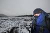
I arrived at Richards campground which is the start of the walk in good time. Passing through the nearby town of Beaufort, a stop was mandatory in order to pick up some pre-hike sustenance. This is a tradition, as a hiker needs a perfectly balanced meal before hitting the track. Yes, the potato pie...

Full of energy providing ingredients, such as, pastry, potato, 'meat' and shredded ferret gristle. An indicator of a good pie is how often after consumption one bends over in pain. After I'd inhaled this one, I immediately bent over double, clutching my stomach, not once, but twice, which proved it was a pretty good pie. Once the stomach contortions settled, I was then ready to 'Blast the Beeripmo' (BTB).
I'll mention one interesting thing about this hike. The first day is essentially uphill and when it's not going uphill, it's heading uphill. I was packing pie-power though, so I didn't feel too perturbed and hit the car park at good speed.
The speed continued as I powered across Richards campground and then hit the track. This was when I first hit the wall, which was slightly ominous as the car was only 50 metres away, but I dug deep as the path commenced to rise. It seems hopping out of a car half-asleep and then climbing a hill is pretty standard fare. It'd be nice to have a few kilometres on the flat to warm up, wouldn't it?
Well, the first attraction of the day was Raglans Falls, so I was looking forward to that. Who doesn't like a waterfall? Being only 30 minutes from the start, I thought I'd get there and have a bit of a relax around the tumbling water.
Mm... There seemed to be a problem though. I understand the terminology of waterfall means, 'water that's falling'. Unfortunately for me, Raglans Falls goes for another approach which is, 'big rock that's dry'. It's an interesting concept, but it creates a piss-poor photo opportunity. I did take a picture, but as it's just a rock, I couldn't be bothered processing it.
There were other things to look at though. Lots of trees for example.

Even some fallen ones, which I had to walk under. Being tall can make this tricky, but there were no problems on this occasion...

You know what? Lying on the couch for a fortnight is not good training for hill climbing. Did you know that or have I just come across a secret? I was in low gear, huffing and puffing like an old steam train and there's a point where I know I'm officially 'putting in'. My knees sweat.

Having a knee sweating good time.
Frankly, the first few kilometres sucked, but once past Raglan Non-Falls the ground levelled a bit. Well, it was still going up, but not as steeply. It was time to look around for things to photograph, which was problematic. With all the birds around, my eyes were peeled for any colourful feathers lying on the ground which would make for a nice picture. Do you realize this is the only one I saw all day? How's this possible? I now pronounce, 'the world's smallest feather'.

There you have it. If you've only come here to look for feathers, then I suggest you head off now.
After the trip I looked at all of the photos taken and they all appear to be identical. Lots and lots of tree shots. Such as this...

...and this...

Mm... I'm not sure how long I can pad out this post with random tree photos, so I'll speed it up a little. The track continued uphill (how did you guess?) passing over Cave Hill. Is there a cave? Did I miss something? Crossing over the odd bush road, whilst taking note of the handiwork by responsible shooters which have passed before me...

If you're going to have a shot at a sign, wouldn't you shoot the motorcyclist in the head? Besides being responsible, they're also crap shots.
Maybe I can help out? Target acquisition is imperative. I suggest get your gun, grab a couple of sandbags to rest against when lying down, and steady your breathing. Sight picture is the key, so don't forget to aim rear sight first, centering with the front sight, then front on the target and finally rear during the shot. Maintain a steady trigger pull whilst ensuring you follow through when squeezing and take that motorcyclists head off. The next time I walk through here, I expect some improvement in accuracy. If not, give me fifty push-ups, followed by lying on your back with legs raised whilst I stand on your stomach for the ultimate ab-workout. Then I'll write a post as a fiasco master-class in shooting for responsible gun owners, so you'll be blasting road signs with dead-eye dick accuracy in no time.
Where was I? Oh yeah, I was hiking and sweating. There was a difference though, as some views were appearing rather than just trees. Mount Langi Ghiran was clearly visible, although a few threatening clouds worried me a little.

Okay, a couple of things about Mt Langi Ghiran. Firstly, in the past I read somewhere the Aborigines described as looking like a pregnant woman lying on her back. I can see that quite clearly, but do you think I can find anything online? Did I dream it? I'm sure that's not the case. The trouble is any Googling I do on the mountain, all I get is crap about the nearby winery with the same name. Couldn't they have used a variation or not included the 'mount' in their title? As it is, any searching I've done comes up with different types of shiraz. Oh yeah, or the walk I did there last year. How has such a great mountain to walk over, got such small online comment?
There were other things to see as well. This grass fire, which I assumed was a burn off in progress, pumped out the smoke.

Dim photos, aren't they? It was quite a dark old day. The sunlight which was shining at the start of my strolling had long gone and I was a little concerned about possible rain. Not that I could speed up and get to camp. I was stuffed and quite astounded at how little I'd walked to the level of pain I was feeling.
Continuing on, the track slowly descended, which had me feeling quite nice. My GPS was informing me the Beeripmo campsite was less than a kilometer away and things were good in the world. Yes, it's time. Let's cue the dramatic music again...
The low-wattage globe in my brain suddenly flickered and hit me with, "Hang on, isn't there a mountain between here and the camp???"
Oh yes, of course there is. At 934 metres Mt Sugarloaf is the mountain in question. Suddenly I saw a huge lump of rock looming between the trees, blocking the sky. In my tired state I'd forgotten all about it. Mt Sugarloaf was my Sergeant Doakes.

Talk about disappointing. When I realised I'd have to go over it, all I could feel is what the Germans describe as the, 'starb in den Arsch Gefühl'. I continued on with my head bowed so dramatically I kept stepping on my chin. Here it comes...

Mt Sugarloaf through the trees.
The way up was not immediately visible, as my eyeballs were transfixed on the huge slab of rock. It became clear though, as I slowly trudged up, the track sidles under the cliff and continues to climb...

Talk about ascending slowly. I was practically in reverse, but eventually I slogged over the top, sighting a summit cairn on the way.

This should have been a cause of celebration, but all I could do was indicate my displeasure at the mountain...

Then a lookout was reached. It's a nice view, if you're not vomiting up through your nostrils the remains of a potato pie...

Mt Sugarloaf lookout
Now, I've been wondering about a couple of things. Were there only about ten words to choose from back in the 1850's? I say this as I think I've climbed about 500 (yes, 500) Mt Sugarloaf's in Australia. Couldn't these clowns come up with some different names? There's stinkin' sugarloafs all over the place and not just mountains. We've even got Sugarloaf Reservoir out the back of Melbourne.
I don't know, but maybe this particular one was named by two blokes who just combined what they were saying at the time,
"Hey Sugar. That mountain looks like a loaf!"
You never know. What I also noticed was a piece of rope lying across the Sugarloaf sign. It really should have been at the bottom, as at least it gives one an option to string themselves up if the approaching hill climb looks too daunting.

Well, that was it. Once my blubbering corpse stumbled over the mountain I was soon at the Beeripmo camp. It's a lovely spot as well. Water tank, comfort station and a number of secluded spots amongst the trees to set up a tent. There's also a few little tables like these to collapse on and not move for an hour or so...

Well, the day was done. Why was it so painful? Let's see if the GPS reading gives an indication...
Hang on. 700 metres climbing in nine kilometres? No wonder I was feeling tired. Mind you, I've mentioned how my couch training was probably not conducive to hill climbing. I'm sure if your physique consists of little more than prick and ribs, you'd wonder what the problem is. Anyway, the show's over for the day. Next up will be day two of this saga...