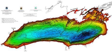
Bathymetry of Lake Ontario
Bathymetry is used to measure water depths to help model physical underwater terrain found beneath large bodies of water. Similar to the same way that LiDAR models are represent 3D features (or relief) of land terrain, bathymetric maps illustrate the terrain or land that is located under large bodies of water. Color ramps created from depth contours or isobaths help make the variations in relief easier to see.
“High-resolution digital bathymetry makes possible meaningful quantitative estimates of available habitats for fish and other living organisms. In other lakes these estimates have been used to formulate regulations intended to prevent overfishing. Conversely, Great Lakes bathymetry is much in demand by anglers as an aid in locating the most promising areas for fishing.”
The Bathymetry of Lake Ontario was the third poster map released by National Oceanic and Atmospheric Administration (NOAA) depicting highly detailed bathymetry data ( at 2 meter contour interval) of the Great Lakes. Click here for more details on the Bathymetry of Lake Ontario data set and use the links below to download the pre-made maps and GIS data:
- Download Bathymetry Contours in Shapefile Format
- Download ARC ASCII Grid data
- Download Wall Size Poster Map (PDF)
- Low res Image of Poster
The other Great Lakes Bathymetry data can also be downloaded here
By canadiangisFiled in: Data & Software, Free Data & SoftwareTags: 3D, Bathymetry of Lake Ontario. Bathymetry, data, download, Lake Ontario, LIDAR, OntarioAlso Check Out ...

Over the past few years CanadianGIS.com has been highlighting and promoting various cities and provinces in Canada that have done a great job providing data and applications to the public.
We created this page a few years ago to collaborate links of all the open geospatial data info (sites that offer data downloads at no cost and without restrictions), fee based geospatial data, online web mapping applications and other great sources of geospatial information (including National, Provincial and Regional levels).
This comprehensive list of open geospatial data, fee based geospatial data, web mapping applications and cartographic products is a valuable asset to many people (… we get hundreds of emails and requests regarding “Where can I find data for …?”) so we continue to update it with new information and sources of Canadian data sets.

The City of Toronto has recently celebrated two years of online Open Data service and they continue to build on that success, by stating that they intend to add more data layers and further develop their online data portal. So with that in mind I thought I would take a closer look at how Open Data Frameworks are currently doing here in Canada.

So far this year Natural Resources Canada has released over 350 updated or new topographic map sheets and made them available to the public in what they refer to as the CanTopo series. CanTopo is considered the next generation of topographic map sheets that provides quality spatial information that fully complies with international geomatic standards.
The digital maps are considered multipurpose because they can be utilized for a wide range of uses from many different organizations and individuals. Georeferenced versions can also be used with Global Positioning System (GPS) receivers and other digital geographic data sets with various software packages such as Google Earth, ArcMap or Global Mapper. You can also simply print them and use them the way they are, as regular NTS paper maps, just like most of done for years.
GIS Tutorial 2: Spatial Analysis Workbook
