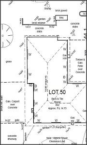
In contour surveying, the surveyor uses contour lines for identifying the variations in the earth's surface height along with the relative places. Contour surveying is conducted with the goal to determine the surface altitude or height.
When viewed from its most basic form, contour surveys depict all elevation changes over a property at the lowest point, starting from the lowest to the highest points. Contour lines connect places at the same height. The contour lines are closer together at the steeper part.
Now, to the property buyers, the contour lines are quite critical. So, when the surveyors are conducting property surveys, then they show the elevation of the land or property by outlining curved lines. Hence, the contour surveys are the "form plan".

Even if the contour lines are determining whether the piece of land is at level or not, still it does not convey that topography has nothing in this regard. When the property is at the same level as the neighbouring land, then the topography will be the same. But if it is otherwise, then the land will have its own topography. If the land is on a hill, then its elevation will be of its own.
By experiencing and understanding the elevation changes, it can be seen how topography has a vital role to play to determine the shape of your land. So, the contour lines hold high importance.
The Characteristics Of Contour Lines in Contour Surveying
These are the characteristics of contour lines that the property or land buyers should know.
- The true presentation of the contour lines is the topographical map.
- Working with the contour lines is easier as these are at fixed intervals.
- Steeper lines on the map indicate higher elevations. These might not be the right ones.
- The vertically going up contour lines from point to point mean the rounded corners are not showing up in these maps.
- With contour lines, the land topography is not accurately shown. To prevent it, a cartographic map with contour lines given at 10 feet intervals other than 20 feet is used.
- Contours affected by maps and aerial photographs, cause the lines to appear distorted - but in reality, they are not.
- The contour interval length from point to point means the radii are not shown on these maps.
The Types of Contour Lines in Contour Surveying And Their Attached Significance
Now let us learn the different types of contour surveying and their significance -
i. Isopleth - Isopleth on a contour map connects the locations having the same value of geographical or meteorological events' measurable quantity.
ii. Isohyet - The points of equal rainfall in a specific region over a given time period are denoted by Isohyet.
iii. Isobar - On contour maps, the Isobars represent the point where the atmospheric pressure is equal or constant for a particular time period. Frequently, the isobars are used in weather reporting on television.
iv. Isobath - The imaginary contour lines on a map or chart linking all places within the same depth under the surface of the water, like the sea, ocean and lake.
v. Isohaline - A form of a contour line on a map connecting equal salinity points in a water body. These are majorly contours.
vi. Isotherm - Contour lines on a chart or map linking points of equal temperature in a specific area. Further, they are classified into two categories, namely Isocheim and Isothere.
a. Isocheim - A line with the same mean winter temperature is the Isocheim.
b. Isothere - A line of equal summer temperature is Isothere.
Isotherm at 0°Celsius is the freezing level.
vii. Isohel - A form of a contour line on a map linking locations with similar sunlight amount for a particular period.
viii. Isohume - Contour line form on a map linking all of the points in a specified area having equal relative humidity.
ix. Isoneph - A straight line linking all places with an equal cloud cover level.
x. Isopectic - Imaginary lines drawn on a contour map or chart linking all the sites where the ice starts developing at the same moment.

Before, property or land is developed, a contour survey should be conducted. even belong to the planning application and design. It comprises all the necessary surveys prepared in a drawing showing all the necessary features and their levels across a given property as well as the relevant adjoining property.
