Nepal has announced plans to go ahead with a planned survey to remeasure the height of Mt. Everest, citing "National Pride" as a reason it is proceeding with the delicate, time consuming, and costly operation. The surveying expedition is expected to take up to two years to complete, and cost somewhere int he neighborhood of $250,000.
For decades the accepted official height of Mt. Everest has stood at 8848 meters (29,029 ft), although there has been some controversy surrounding that figure. For instance, the Chinese measured the summit in 2005 as 8844 meters (29,015 ft), with surveyors claiming that was the altitude without snow on the summit. Meanwhile, a 1999 GPS survey by the National Geographic Society lists the height as 8850 meters (29,035 ft), further confusing the subject.
So what's the real height? Nepal is embarking on an ambitious plan to find out, and has rebuked any outside help. The country that claims dominion over the South Side of the mountain has never measured the height of Everest on its own, and is now intent on doing the fact that neighboring India has already announced its own plans to measure the mountain again as well.
The impetus behind these recent plans to survey the mountain once again come following the devastating earthquake that hit Nepal back in 2015. It is believed that the seismic forces that caused that disaster may have also caused Everest to shrink in height. Most reports indicate that the mountain probably only lost an inch or so, but that was enough to spur on talks of remeasuring the peak, with India first announcing its plans to send a survey team, and Nepal quickly following.
The Nepalese government has been quietly preparing to check the height again and this fall it will wrap up its preliminary work and methodology, before opening it up to scrutiny from international experts. If all of the plans pass muster, a team of Sherpas will carry precise GPS equipment to the summit of Everest next spring or fall, depending on scheduling. That equipment will work in conjunction with surveyors in other parts of the Himalaya, which will be taking measurements from a variety of vantage points.
When asked why Nepal is conducting its own survey Ganesh Prasad Bhatta, the government official overseeing the project, said “It’s the government’s responsibility to make sure that its citizens feel good about their country.” He want on to add “We need to let them feel that government invests in knowledge about its natural resources.”
This begs the question, is "national pride" a good enough reason for the Nepali government to spend hundreds of thousands of dollars to remeasure the mountain? Nepal is a poor country, and it is still recovering from the earthquake. It would seem that its resources would be better spent elsewhere. At the very least, perhaps joining forces with India would make sense, rather than completely going it alone. Instead, the government is embarking on another course of action that seems likely to result in wasted funds and most likely corruption. Don't be too surprised if when this survey is complete, we'll discover that it cost twice as much as first allocated, as officials line their own pockets along the way.
On the other hand, we may finally get an accurate assessment of just how high Everest truly is. But what happens if that height is actually 8848 meters, just as we've always known?
Thanks to my friend George for sharing the news on this story.
Outdoors Magazine
With "National Pride" at Stake, Nepal Prepares to Remeasure the Height of Mt. Everest
Posted on the 21 September 2017 by Kungfujedi @Kungfujedi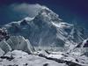
Magazine
COMMUNITY OUTDOORS

TOP MEMBERS
-
 kungfujedi
680781 pt -
 t_mackinnon
321884 pt -
 Behan Gifford
224577 pt -
 everywhereonce
221598 pt