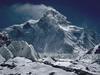
The government in Nepal has requested that the height of Mt. Everest be re-measured in an attempt to gain a more accurate reading of its true height and to end a brewing dispute with China. For years, the official height of the mountain, as recognized by Nepali officials, has been 8848 meters (29,029 ft), but that measurement includes 4 meters of snow on top of the peak. China insists that the mountain should be measured sans snow, and they list the height as 8844 meters (29,015 ft).
Everest falls along the border between Nepal and Chinese controlled Tibet. Apparently, last year the two countries agreed to use the 8848 meter height while discussing border disputes between the nations, but the Chinese continued to use the lower height. In order to settle the dispute once and for all, Nepal has begun the task of re-measuring the mountain using sophisticated GPS devices. Measurements of the height will be taken at three different locations, and the entire process could take up to two years to complete.
It should also be noted that in 1999 an American team measured the height of Everest, using GPS equipment, at 8850 meters (29,035 feet). That is the same number that National Geographic uses in its publications and representations of the mountain. The new survey will be the first official measurement since that time, and since technology has increased in sensitivity and accuracy, it is likely that this will be the most accurate measure of the height of the mountain to date.
It should be interesting to discover what the survey teams find when they compile their data. Maybe we should start a pool now as to what the height will be.